I've been going back and forth as to whether I want to go through the effort of documenting my adventures in the outdoors. Yesterday's excursion into the Matilija Wilderness solved this dilemma. Not everyone has the time or desire or ability to venture off into places known or unknown, near or far; with this blog I hope to bring these places closer to home. If you are looking for a detailed description of a route or maybe a KMZ or GPX file I'm afraid you are out of luck. I hardly ever use a GPS and am not very skilled in navigational writing. I just tell the story and offer neat pictures.
Anyways, back to the excursion. For awhile now I've been eyeing the glistening pyramid of white sandstone that marks the face of a peak known as Cara Blanca. If you've ever been up the Matilija Creek Trail, you know what I'm talking about. At 4,860ft, the mountain is clearly visible from many places in the canyon. Take a quick drive up Sulphur Mountain Rd and you can see it tucked away in the north west. Sometimes on a clear day it can even be seen from the Conejo Grade on Highway 101. It looks like nothing else in the general area, sticking out like a sore thumb. And hardly anyone knows about it.
There is pretty much no information that exists about this elusive mountain. The only thing I could find was an invaluable trip report written by the legendary David Stillman. After reading his report several times, I realized that 1. This mountain is no joke and 2. Hardly anyone climbs it. The last evidence of someone successfully summiting this thing came from a comment on Stillman's report posted in 2019.
In short, this mountain is definitely outside the realm of comfort. But what the hell, going through discomfort makes the comfortable all the more enjoyable. After vigorously studying the layout of the mountain on Google Earth, reading Stillman's report just one more time, and convincing one of my long time friends that this would be really cool, I decided to finally climb the damn thing.
 |
| West Falls |
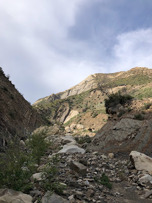
At around 8:00am we arrived at the Matilija Creek Trailhead. Having been here many times before we breezed through the canyon all the way to the West Falls in record time. It was a beautiful morning; you couldn't ask for better weather. After scaling the falls we headed up west falls canyon for a little ways until we reached a spot where we thought we could gain the southeast ridge. There are many ways to climb this mountain. Some are shorter than others, some are harder, but all of them suck. The southeast ridge was no exception. But that was our chosen route and that was what we were gonna do.
 |
| Finding the least strenuous route on the Southeast Ridge proved difficult |
Maneuvering up the southeast ridge was slow work. The ground is made up of loose rock and shale. In some instances, the shale is so incredibly fine that it felt is if we were climbing a sand dune. Additionally, the going was steep. Especially as we made our way up what Stillman labeled "Sub Peak 2." Climbing on all fours, sometimes holding onto brush for balance and support, was necessary in some places.
 |
| "Sub Peak 2" |
As we were slogging our way up to "Sub Peak 2" we caught sight of a deer grazing on the hillside. It took one look at us and began bounding effortlessly up the mountain. Wish we could do that. Once we reached "Sub Peak 2" we took a ten minute break and discussed our plan of attack. From here we could clearly see the very steep south face of the mountain. From here to the summit is probably the most strenuous part of the climb. The mountain just keeps getting steeper and steeper as you go. So we decided on taking the most direct approach to save as much energy as possible.
 |
| Our Proposed Route |
Staying true to our route was surprisingly simple. The only problem was the grade and the brush. The grade fluctuated between 45 to 50 degrees, sometimes a little steeper. We kicked down many good sized rocks and had several close calls as the ground we stood on suddenly gave way. The brush made travel very slow, but at least it offered something to hold onto when we slipped and slid on the uncertain terrain. After about an hour we finally made it to the final push. This is the most difficult portion of the climb, but as long as you take your time and stay true to your route, it really isn't that bad.
 |
| The Ol' Spiderman Technique |
Here we began to climb one person at a time because of how many rocks we were kicking down. At one point the ground beneath me completely gave way, sending a whole cascade of head sized rocks down towards my friend. "Rock! Rock! Rock!" I shouted, hoping to stop the inevitable. Luckily he was able to dodge most of them, one grazing his arm. That was close. From then on we were incredibly careful where we tread.
 |
| The sandstone face, close to the summit |
After making it through the worst of the shale, the mountain becomes much more agreeable. The last 100ft to the summit is actually very pleasant, with fairly stable ground and minimal brush. The summit itself is marked with a little sandstone duck. On one of these stones are the names of those who have conquered the mountain. With truly breathtaking views of the surrounding Matilija Wilderness, the trip was well worth the effort.
 |
| Crazy People |
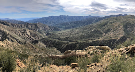 |
| View from the Summit |
This peak is truly something else. If you are comfortable with off trail navigation and are in decent shape, this mountain will still prove difficult. This is not an easy mountain. There are no easy ways up this thing. I guess that explains why so few people have been up there.
Stillman's register melted away in the Thomas fire so we decided to bring one of our own. According to him, "coffee cans are sooo passe," so in honor of that thought my friend hauled up an empty ammo can. Was it heavy? Yes. Worth it? Maybe. But hey, that thing ain't going anywhere soon.
 |
| New register |
After soaking in the summit one last time we started the long and steep descent down to the west fork. Going down is considerably easier than going up. Luckily, we were able to avoid that sketchy shale slide that was causing us so much trouble. Plus, sliding down on loose ground is always better than climbing up loose ground.
 |
| The view back down |
After awhile our legs finally started to feel the burn. Constantly descending a steep grade does wonders on the knees and quads. But none of that really mattered. We had reached our goal and were glad that we did.
When we finally dropped back down into the west fork we knew the worst was over. Now all we had to do was rinse off the char and dirt in the spectacular West Falls.
 |
| Always go into the water (unless you are hypothermic) |
 |
google sucks as far as being easy to comment. Your report and pictures are nice but where are the ties mr shirt and ties adventures.
ReplyDeleteAh, hello G-pa. Google can be a pain in the butt sometimes. Shirt and Tie adventures are soon to come
DeletePretty cool! Nice summary of the trip.
ReplyDeleteAwesome adventure! I would have died, so thanks for the pics cause I'd never see them on my own
ReplyDeleteI've been working out and building my cardio so next break I get let's get a few hikes in
ReplyDeleteY’all are a couple of legends
ReplyDeleteSean, what can I say? The photos, the story, the voice.. For the love of God, keep making these <3
ReplyDeleteThis was great! Loved the pictures and the writing was engaging and relatable, yet very knowledgeable. You have such a distinct voice in your writing that is so enjoyable to read. Can’t wait to read the next one!
ReplyDeleteI never expected to hear that this peak had been repeated, and even less so by a different route than I took. Congratulations. From Montan, and with some admiration, Stillman.
ReplyDelete