
I used to think that Haddock Mountain was Reyes Peak for the longest time. It's a lot more impressive than Reyes, with stunning cliff bands dotting its southern face. I always just assumed that this was Reyes Peak because it looked a lot more interesting and rugged than anything else in the area. And then I climbed Reyes Peak back in April and realized my error. Actually, in all honesty, I had already realized my error long before when I took a close look at a map and said something like, "Gee, that ain't Reyes Peak! Man I'm such a goober!" But I never trust something 100% until I get out there and see it and experience it with my own eyes. And, sure enough, I saw a mountain that rested east of the summit of Reyes Peak, the mountain that had all those impressive cliff bands and sheer drop-offs. This alluring, pine-covered peak that I saw was Haddock Mountain. And I knew right then and there that I had to climb it one day.
For whatever reason, I rarely frequent the Pine Mountain Ridge area. I've only been up there a handful of times, mostly hanging out near the campgrounds, climbing the rock formations closest to the road. As of right now, I've only climbed Reyes Peak three times, two of which occurred this very year. It's an absolutely beautiful area, one that I would argue is one of the most beautiful in the entire Los Padres. Reyes Peak, Pine Mountain Lodge, Thorn Point—these are just a few of the several awesome places that exist in this area. The mixture of huge sandstone rock formations and boulders with tall Jeffrey Pines and old growth forest give these places an otherworldly feel. It's unlike anywhere else of which I know.
I've been to Pine Mountain Lodge a few times. Thorn Point even more so. I've walked the entire Gene Marshall Trail and even summited Cedar Peak twice. But for some reason or other I'd never been to Haddock Mountain. Neither had Grace. So yesterday, around 10:30am, we decided to give it a little looksie.


Thankfully, the weather was on our side. Last week's temperatures soared to the hundred and teens. Them's some diabolical temperatures right there. Not ideal for hiking. Or for anything, really. But that morning the temps were hovering in the upper 70's. When we made it to the trailhead, at noon, the temps had dropped to the mid 60's.
There was a constant sweet vanilla scent of pine floating through the air. Scattered clouds drifted ahead, pine needles rustling in a light breeze. There was just one other car in the whole lot. Several stone figurines littered the dash. I made out an eagle and other forest creatures. Perhaps they were magical totems of some kind. Who's to say.
We started at an easy pace. Grace hadn't been on a hike all summer so we kept it slow, enjoying the scenery and the perfect weather. The trail rests on the north of a long undulating ridge, following it for a ways before dropping down to a junction with the Gene Marshall Trail. We would not go as far as that. Haddock Mountain was about four miles down the trail, well before the junction with the GMT. Most of this trail is in the shade of the pines, which makes for good walking. Along the way, we made out Mt. Pinos to the north as well as the Cuyama Badlands, the sunlight casting shadows on the numerous rugged hills. We could even see the gray burn scar courtesy of the Apache Fire.

 |
| Haddock Mountain |
 |
| Big ol' pine cones |
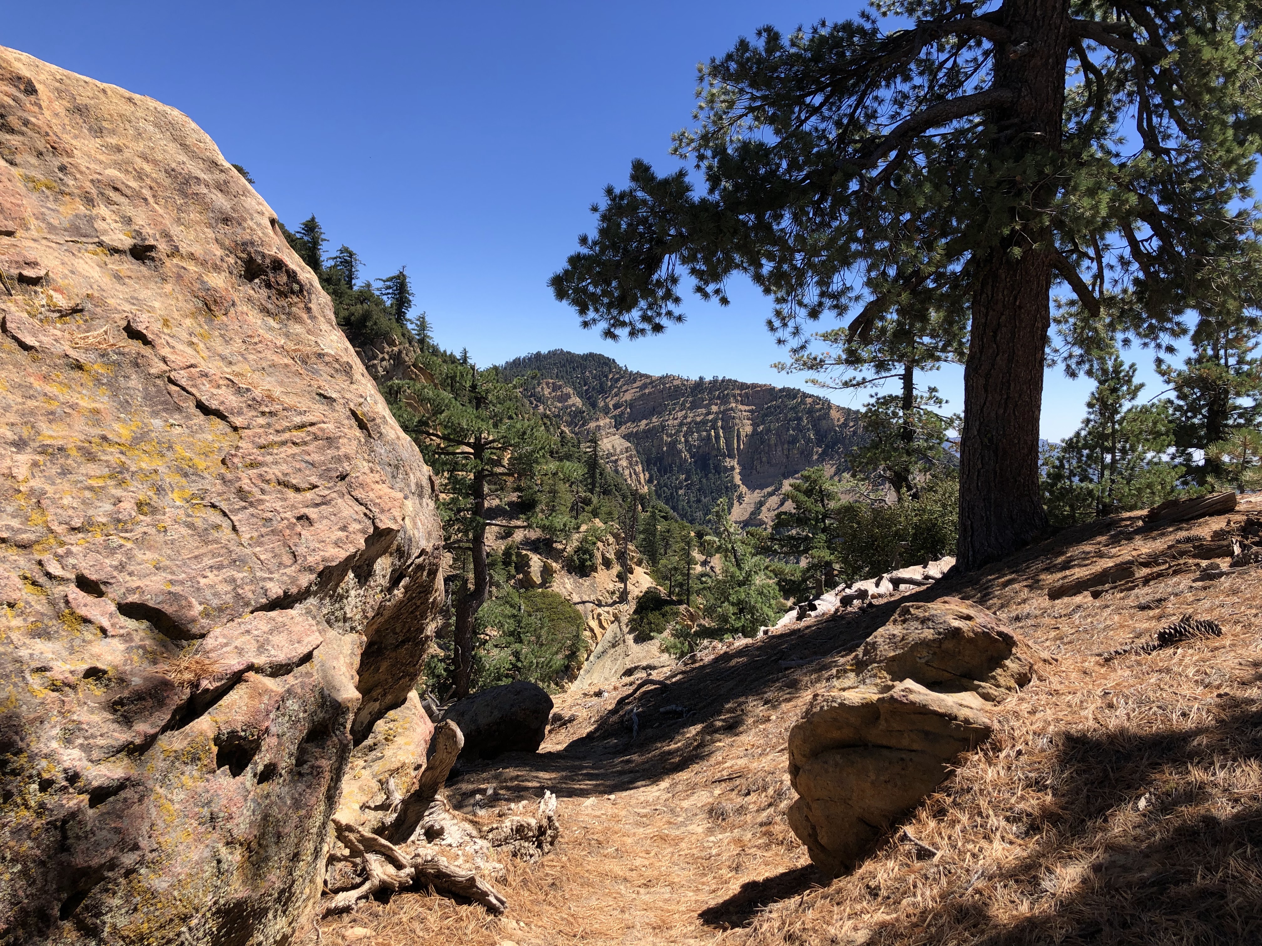
We followed the trail, which weaved its way in around and through the beautiful pine forest. Several of the trees had sagging branches. On the end of each branch was a big ol' pinecone or two, swollen and ready to drop. Every now and again the trail would gain the ridge and we'd be gifted with views of both sides of the wilderness: the Sespe River, Topa Topa mountains, and the urban sprawl of Ventura and Oxnard to the south and to the north: the Cuyama Badlands, Cuyama Peak, and San Emigdio Mountains. Haddock Mountain stood a ways off, its impressive cliff bands dotted with splotches of neon green lichen.
We continued on, Grace documenting the adventure with a camcorder. We walked along several little ups and downs, weaving around huge sandstone boulders and rock formations. This whole ridge is a bouldering paradise. One could spend a lifetime going off trail and exploring and climbing all of the boulders that are scattered around this ridge. There's more than the eye can count. But since Grace and I aren't rock climbers, we stuck to the trail, appreciating these grand boulders and formations in passing.
 |
| San Emigdio Mountains |
We stopped once, finding a nice spot on some rocky slabs in the shade. The trail continued up these slabs, the way marked with a small cairn. We spent a good ten minutes gazing north, staring at the San Emigdio Mountains to the north. Cerro Noroeste, Grouse Mountain, Sawmill Mountain, and Mt. Pinos were all visible. Everything smelled fresh and clean, the whispering breeze carrying with it the taste of autumn.
We continued on, following the cairn and then heading up, towards the top of the ridge. Grace said hello to somebody and I turned and saw this guy bouldering. He was staring right at me, like he'd seen me for a long time. Goes to show how observant I am. He had a bunch of crash pads set up and was busy working on this one boulder, his hands caked in chalk. This must be the owner of that car with the totems. He was the first and only person we would see all day.

By this point we were pretty close to the summit. We stopped a few times on the top of the ridge, observing the sheer drop-offs and steep chutes that fall into the Potrero John drainage. We started going up some steep switchbacks, walking through a swarm of bees that were making their home in a Jeffrey Pine right next to the trail. I wasn't entirely sure when to leave the trail, but I knew from the map that it should pass right beneath the summit. So we saw a high point, left the trail, and went for it.
I wasn't confident in this decision. For one, there was no use trail. And when we eventually made it to the top, there was no sign of a register. In fact, there was no sign that anyone had been there for a long time. Huge rocks, tall trees, an undisturbed carpet of pine needles—this didn't seem right. And finally, after exploring for a minute, we saw another high point a bit further to the east. That must be the summit. But we'd been hikin' for two hours by this point so we decided to take a long lunch break. We climbed up some small rocks and ate our lunch whilst enjoying the stunning view to the south.
 |
| Lunch Spot |
 |
| View from lunch spot |
There was a tiny bird that came and said hello. It chirped and squeaked and then flew off, never to be seen again. We noticed a few flat areas in the shade of some pines that would make great tent spots. It was very peaceful up there, only hearing the sounds of the birds and the breeze rustling through the pines. After our lunch, we packed up our stuff and headed east for that high point, walking through dry grass and weaving through boulders.
We picked up the trail and followed it to that high point. I was sure this was the summit. So we left the trail, once again not noticing the presence of a use trail, and started the short climb. The top of this high point was a flat, unassuming spot that was covered with yet another undisturbed carpet of pine needles. Again, there was yet another high point just a bit farther to the east. Man. That had to be the summit. How many bumps can this mountain have? So we left this second high point, Grace no longer trusting my intuition.
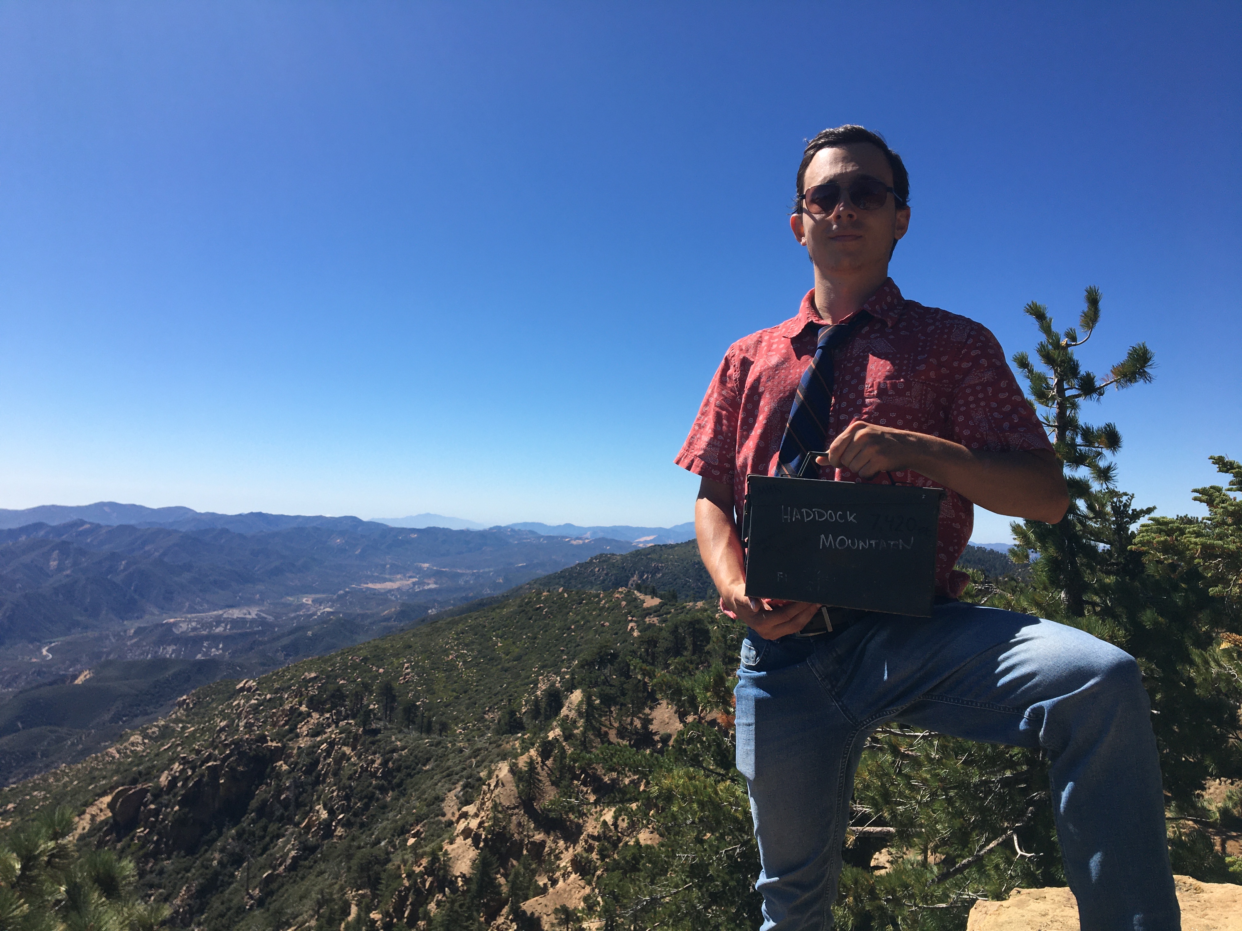
We picked up the trail, and this time it practically took us to the very top of this third final high point. Sure enough, this was the true summit. A new ammo can register rested in a water-carved hole on the summit boulder, the name "Haddock Mountain" written on one of its sides.
 |
| Leaving the lunch spot |
 |
| The Second High Point |
 |
| Third time's the charm! |
The register was placed in May of 2022. The guy who placed it seemed to have had the same issues we had in trying to find the true high point. There was a note under the entry reading, "Move to correct bump if this is not it." Given that the register has been there for two years, containing within it a few signatures from some Los Padres diehards, it's safe to say that this spot is the correct bump. Don't worry Brett. You found the right one.
The last entry was from September 3rd of this year. We left our signatures and enjoyed the view, happy to have finally made it to the top. The views were much of what we had seen throughout the day, just from a slightly different angle. Reyes Peak stood a ways off, pine-covered and rocky. I thought about tagging it on the way back, but that would depend on how Grace felt. Plus it would be completely superfluous and unnecessary since I'd already climbed it twice this year. We'd cross that bridge when we got there.


 |
| Reyes Peak left |

 |
| Topa Topa Bluffs middle |
After taking our fill, we climbed down the summit boulder and made our way back. We climbed over some deadfall, gingerly walked through low-lying buckthorn, and tried not to slip on the numerous pine needles that covered huge portions of trail. It was just as scenic going back as it was heading out, the afternoon light giving the ridge a different feel. The rock climbing guy was still there, still working on that same boulder. The man was dedicated. We said hello again, he waved, and we never saw him again. He's probably still up there working on that boulder to this day.
 |
| Cuyama Badlands |

Grace was starting to feel the miles so we slowed our pace, taking more time to enjoy the scenery. I stopped a few times to snap some shots of the lichen growing on the sandstone boulders. Neon green, bright orange, pale yellow. It looked like dry, cracked paint. Weird to think that this stuff was actually alive.
We made it a point where the trail gained the ridge below Reyes Peak. There was a use trail that would take us to the summit. I asked Grace if she wanted to go for it, and she said no. So we stayed on the trail, banging out the last few miles at a leisurely pace, taking our time, watching the afternoon light filter through the pines.
 |
| Reyes Peak |


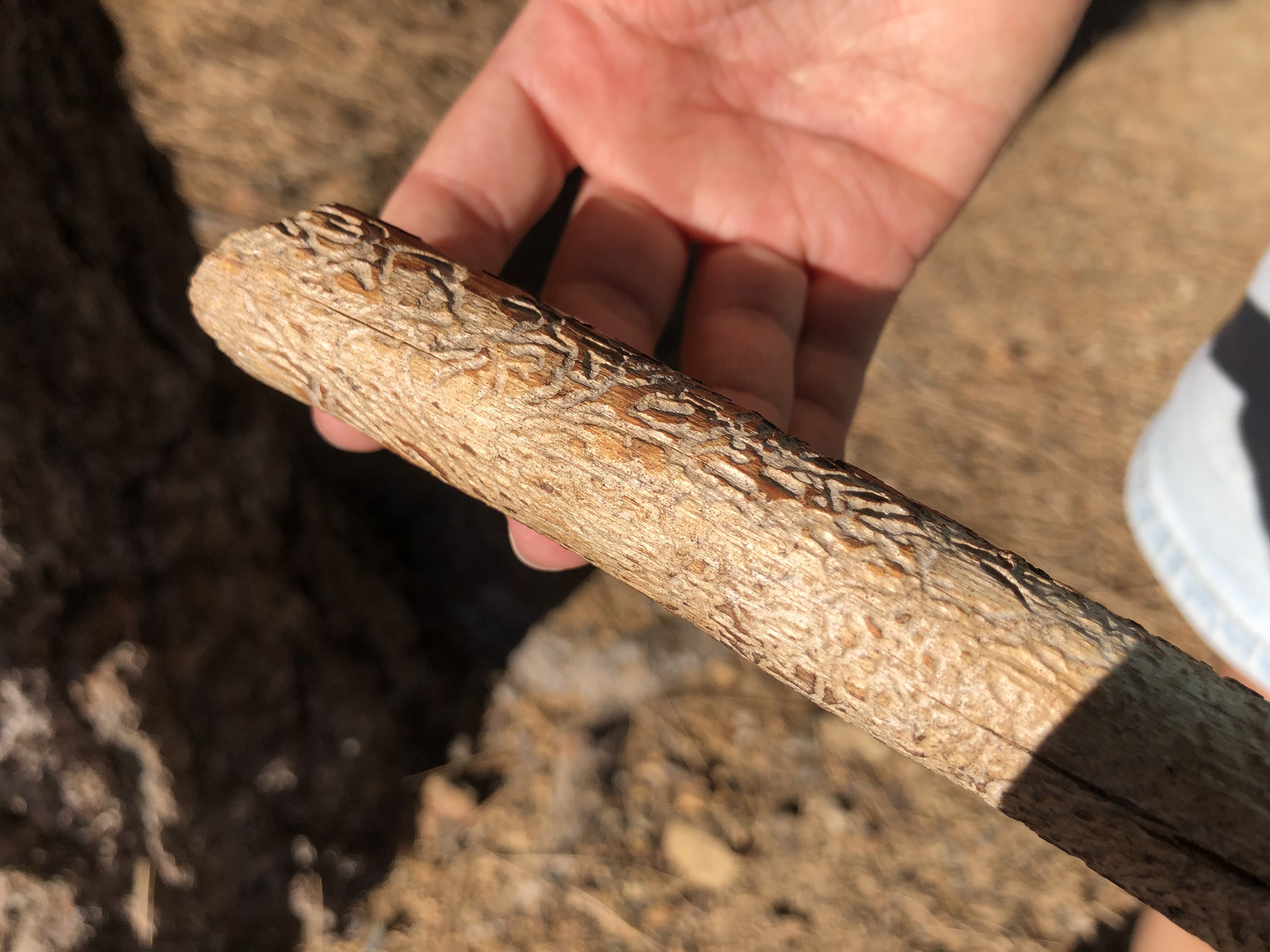
We made it back to the trailhead a little after 5:00pm. Grace said goodbye to the stick she'd been using for much of the hike. It was a cool stick, covered with all these lines and ridges. I think some type of worm or beetle or parasite was responsible for this art, carving these designs into wood underneath the bark. Whatever it was, it left no signature. Must have wanted to remain anonymous.
 |
| Grace's cool stick |
It was hard to leave that stick behind. She left it leaning on a tree right next to the trailhead. We got in the car, waited for it to warm up, and then we slowly made our way off the mountain, driving with the windows down all the way to the 33. It had been a very scenic and relaxing day, although Grace's legs would say otherwise about the latter. Haddock Mountain had proved to be a fantastic summit, with stellar views of the upper Sespe watershed and beyond. The trail from the parking lot to the summit is one of the most beautiful I've ever trekked; I can't believe I've waited this long to finally get to hikin' it.

You are getting better and better with your descriptive writing. Keep it up! Can I find any of your work published anywhere? If not, I truly believe you should.
ReplyDeleteThanks! So far, this blog is the only place I've published stuff. I don't have much anything else that I could publish at the moment, but it is something I've considered.
DeleteAll this talk of a relaxed, leisurely pace... yeah, leisurely for you maybe. My legs were sore for DAYS afterwards!
ReplyDeleteNice writing bro, you keep getting better and better :)