I've visited the ol' lookout tower on Nordhoff Peak more times than I can remember. It's a nice little destination that can be accessed by nice and easy, well maintained trails. But you can only go up Pratt or Gridley so many times before they become routine and predictable. Turns into more of a regimented workout than a relaxing walk. So you start doing combinations. You start at Cozy Dell and then go up Pratt to the top. Or you drive up the 33 to Rose Valley and take the Howard Creek trail to the top and then descend either Pratt or Gridley. Or you start at Shelf Road, go up Fox Canyon or Lucy's Trail to the Fuel Break Road and then on to Pratt or Gridley to the top. Or you start at Shelf, take Lucy's to the Fuel Break, go up Pratt to the summit and then down Gridley and across Shelf back to the pipin' hot car that's been sittin' in the sun too long. And when you get tired of doing that, you start ditchin' Gridley and Pratt at random points and go up random canyons and whatnot hoping to find some cool route that you can take to quench your thirst for exploration for just a little bit until you need to find some other silly way to slice that cake.
This past Wednesday I decided to attempt a route to the summit that I've been wantin' to try for a good long while now. You access the summit via the Northwest ridge, starting near the Wheeler Gorge Visitor Center. To make our trip a little longer (the whole ridge is just under 2 miles) we decided to descend Pratt on our way back. The ridge looked short, steep, slightly brushy, and highly doable. My mother and uncle tackled this very same route when they were my age so you know I just had to do it. At around 7:40am, with one car waiting for us at Pratt, Daniel and I laced up our shoes and crossed the highway and began the hellishly steep first section of the ridge.
 |
| The start of the ridge, just past the leaking rock beyond the last tunnel |
The first section of this ridge is a little demoralizing. It's steep. Crazy steep. The type of steep that forces you crawl on all fours and makes you feel like losing your breakfast. And the ever present loose shale prevents you from gettin' solid traction so you end up in this funny situation of takin' one step forward and three steps back. And you can't see beyond the first hump and then you begin to wonder if the rest of the ridge is gonna be this steep and loose because if it is then you definitely should've brought more water because brother—it's gonna be a long day. The only positive thing about this first section is that once you actually make it up to the ridge line from the highway the brush is practically nonexistent; though it would have been nice to grab it and use it to pull ourselves forward.
 |
| Steep! |
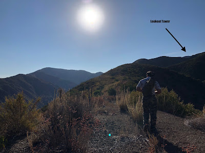
After gettin' our butts kicked on this first section we were pleased to see that the rest of the ridge looked incredibly pleasant. Once we surpassed the first hump we were gifted with our first view of the lookout tower. Even though it looked pretty far away, we knew that we could get there; the worst of the day was behind us. Smooth sailing from here on out!
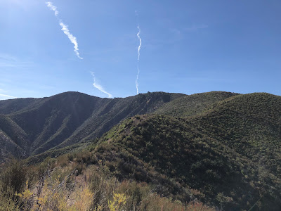
There ain't nothin' better than walkin' on a good ridge. It's impossible to get lost, the views are fantastic, and the brush—minimal. Occasionally we would plow through a small forest of laurel sumac and chamise and sage and buckwheat and yerba santa and a collection of prickly and pokey miscellaneous chaparral, but for the most part the brush was not that bad at all. There appeared to be a faint use trail or animal trail snaking its way up the ridge line; we used this to our full advantage.
After a little while the use trail snaked off the ridge and skirted around a brief steep section. Curious to see where it went and eager to get out of the already boiling morning sun, we followed this trail a little ways until it completely disappeared into the scraggly brush. It took a lot of extra effort to re-gain the proper ridge line so if anyone were to attempt this route I highly recommend just sticking to the ridge the whole way up. It'll save you a lot of time and sweat.
 |
| Leaving the ridge |
Once we made it back to the ridge we took a little breather. Drank some water. Chatted a little bit. By this point we had been hikin' for a good hour and a half and we were a little fatigued. Shirts completely soaked through, streaked with pollen and stickers and thorns and char. Arms scratched and glistening and covered with buckwheat dust. The sun was unkind to us, and in a few hours there wouldn't be a single shady place on the entire ridge. Maybe next time we'll climb it in winter. Just an idea.
 |
| Highway 33 |
We pressed on, the view of the surrounding country gettin' better and better with each step forward. Nearer the top of the ridge, most brush disappeared, and we were able to poke around and find some shells and fossils and old rusty saws and ancient stoves and exploded propane tanks and other artifacts that probably haven't been seen in a good long while. And from here we could see the lookout tower and Chief Peak and most of all of the Matilija backcountry and the zigzaggin' Ortega Trail and Dry Lakes ridge and beyond. And so far, much to our delight, we hadn't seen a single sign of reptilian activity
all day long. That's always a great thing. Especially when it's summer and your walkin' in a place where you won't see the snake until the snake sees you.
 |
| Nordhoff Peak |
 |
| One of the things we found |
 |
| Not sure what this path is. Deer seem to like it. |
 |
| Matilija Backountry |
In just under 2 hours, we finally made it to the end of the ridge. Looking back at what we just did, it was hard to believe that we hadn't even walked 2 miles yet. It looked much farther. But that's just the nature of this particular ridge. It's like Hemingway's writing: short, concise, sometimes brutal but always rewarding. I will definitely use this route again in the future. Much more fun than Gridley and Pratt.
 |
| The last chunk |
 |
| End of the ridge |
We left the ridge and made our way up the road. After walking through steep and brushy terrain for nearly 2 hours, this road was a godsend. We made it to the tower just before 10:00am and took a nice long break, enjoying the lovely midmorning atmosphere emanating forth from the civilized humdrum to our south.
 |
| No marine layer=stupidly hot day |
Since we were feelin' pretty stoked about completing our objective relatively quickly, we decided to take the long way back by descending Gridley to Shelf. Good thing it was all downhill. As the sun got higher so did the temperature, and by noon the breeze was no longer cool and the heat berated our beings as it bounced off the unforgiving and dry and thirsty slopes and slides and canyons. We didn't see a single person hikin' up Gridley; had the whole trail to ourselves. And when we eventually got to Shelf we only saw a handful of fatigued individuals walkin' with their shirts off and carryin' jugs of water. By the time we got back to the car at the Pratt trailhead we were pretty spent but satisfied upon experiencing another great day in the local wilds.
 |
| Gridley |
 |
| Shelf |


I have walked that ridge, but not from where you began. Interesting as usual.
ReplyDelete