
I left work on the 16th and hit the road, bound for the Cottonwood Lakes trailhead. Made a quick pit stop at home to pick up some forgotten supplies and then made my way over to San Francisquito Cyn. There were a lot of cars making their way up the narrow and windy canyon road. We were almost bumper to bumper. Someone was driving real slow up ahead, causing the buildup in the back. Once everyone got in the desert, things opened up a bit, with people turning off the road down mysterious side streets of which I knew nothing about. I drove to the 14 and took that to the 395, stopping in Mojave at a gas station to purchase tomorrow's breakfast.
It was still hot in the evening, almost 100°. With the help of last rays of sunlight setting behind the mountains I was able make out a giant plume of smoke drenching much of the desert to the north. Oh great. That was exactly where I was heading. After I passed Ridgecrest I became enveloped in a wall of dense smoke. It almost looked like I was driving through a heavy marine layer, except that it smelled heavily of campfire. Hardly anyone was driving on the highway. I passed the Coso Junction rest stop, barely able to make out the lights and cars sitting far off through the haze. It was 95° at 9:00pm, smoky, silent and dark. If it was this smoky at the trailhead I would really be in for an interesting hike.
I considered that the smoke was only sitting in the valley. But as I made my way up Horseshoe Meadows Rd, I was proven wrong. The smoke was just as thick in the mountains as it was in the valley, the nearly full moon looking like a burnt orange in the sky. I pulled into the parking lot and nabbed a spot really close to the trailhead and turned in for the night.
I woke up just before 5:00am, had breakfast, and then laid around under my nice warm blanket for a while, waiting for the sun to come up just a little higher. I got out of the car and immediately noticed that the skies were clear and the air fresh and crisp. No smoke! Guess the wind blew it all away overnight.
I set off on the trail a little while later, walking through a quiet pine forest. I spent much of the morning walking through this forest. It was a very gentle trail, not really gaining or losing much elevation. Nobody else was out on the trail. At around three miles I made it to the John Muir Wilderness, and a little ways beyond that I reached a fork in the trail. Turning right would take me to Old Army Pass, which I've heard is shorter but possibly harder since the pass trail isn't properly maintained and because it holds onto snow later in the year. Turning left would take me up New Army Pass, a little longer but very straightforward. I decided to take New Army on the way up and then check out Old Army on the way down. If it was blocked with snow I'd just have to turn around and take the long way back down New Army.


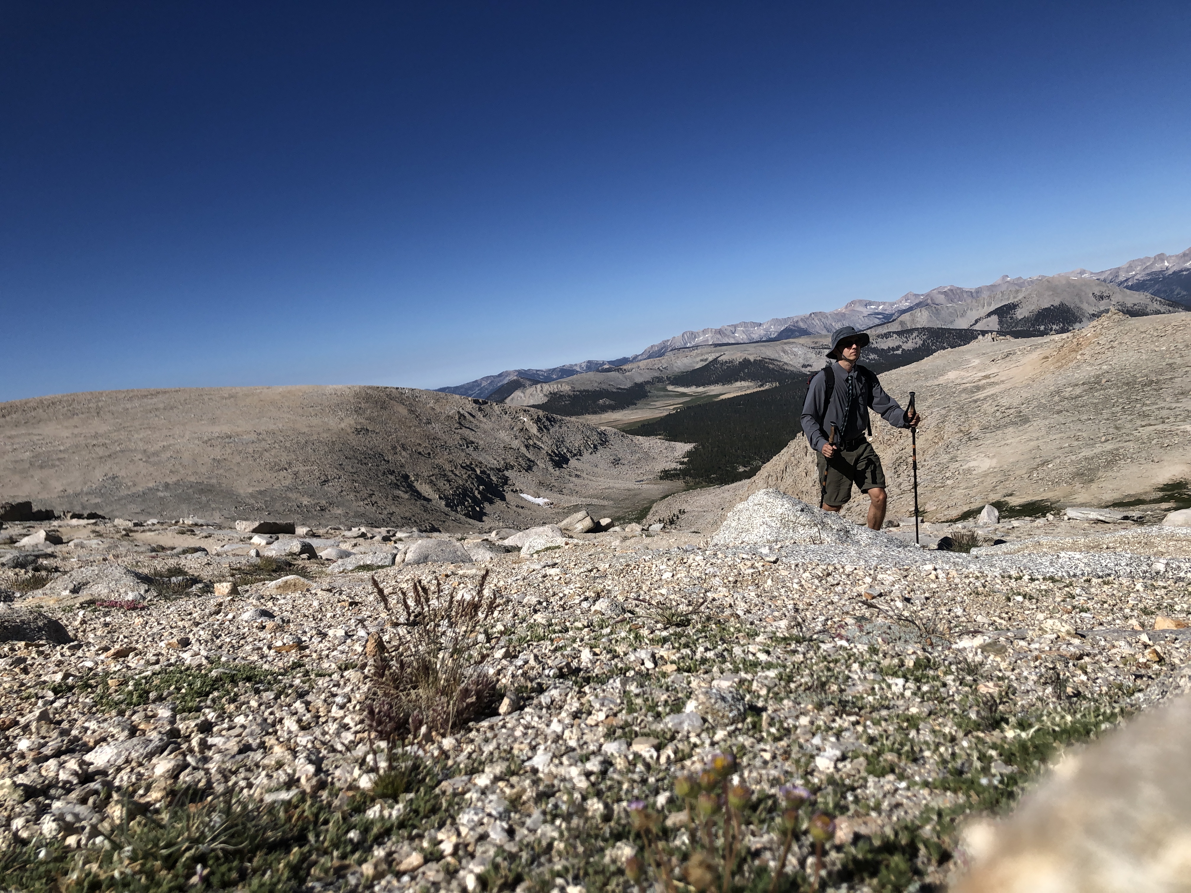
I turned left and started gaining some elevation for the first time that day. I crossed a creek and then meandered my way through the pines, daydreaming about other things as I made my way up the trail. I eventually reached another fork in the trail and turned right, heading towards New Army pass. I got to the top of a rise and was gifted my first view of Langley and the stunning basin that lay before it.
 |
| Mt Langley center right |
I took my first break here, admiring the scenery. The whole basin was filled with alpine lakes and meadows, all of which were surrounded by towering peaks and cliffs and exposed granite. There were several marmots out and about. Some of them were scurrying around, others were loafing on rocks, and a few were just screeching into the sky, their cries a shrill whistle in the otherwise quite morning.
I set off down the trail, passing Cottonwood Lake #2, marmots, boulders, and shrinking pines. Eventually I got to a spot where I could see Cirque Peak, which I had climbed back in September of last year. I reached Long Lake, passing the first people I'd seen all day. I re-filled my water supply, took another break, and then made towards the pass.

 |
| Cottonwood Lake #2 |
 |
| Long Lake |
There were more people on the trail, but nothing compared to Whitney. I noticed a group camped near the west end of Long Lake cooking breakfast and gearing up for what I assumed was a day hike to Langley. Cirque Peak was now in my full field of vision, towering above me like a giant granite pyramid. I reached the timberline and entered the zone of rocks, rocks, and more rocks. High Lake, the last one before the pass, was surrounded by 1,000ft cliffs on its northern shores. There were two tents on its western shore; I could see people filtering water. A little ways past High Lake and I was on the many switchbacks that led to the top of the pass.
 |
| Cirque Peak |
 |
| High Lake |

I was making good time up the switchbacks. I passed two parties also making their way up, one a group of older guys carrying big packs and the other a duo of younger guys with small daypacks and neon glasses and sun hoodies. As I made my way up the switchbacks, I could make out the country that I had just travelled through. The lakes spread before my field of vision, glistening in the morning sun and spilling out from the reaches of an impressive glacial cirque. The Owen's Valley sat a far ways off, seemingly free of smoke. There was a bit of haze sitting beneath distant peaks to the east, and I could just make out a faint plume of smoke rising from the south. I reached the top of the pass without much difficulty and got a great view of the rest of what I had to hike.
 |
| Mt Langley from New Army Pass |
At 12,300ft, I didn't find much wildlife loafing around the top of the pass. Langley stood a few miles away, barren and impressive. I found a nice rock to sit against and chowed down on some yogurt covered pretzels. The two young guys caught up to me, took a break about 10ft away from where I was sitting, and then carried on towards the summit. Two french ladies carrying very large packs were walking up from Old Army Pass. I asked them if there was snow and they said there was no snow. Alright! Looks like I was definitely gonna take the short way back.
I set off a few moments later, losing about 300ft in elevation as I walked down some more switchbacks to the junction with Old Army pass. On my way down I saw some more marmots scurrying around and sitting on their haunches. What they were doing all the way up there I do not know. They, along with the birds, people, and some tiny little plants, were the only living things that could be found at this altitude.
I reached the junction and turned left, following a well marked trail all the way to the base of Langley. This part of the trail was very similar to that which I walked earlier in the morning, except this time there were no pines. It slowly gained elevation over a long distance, taking me higher and higher into the land of wind and rock.

Eventually, the trail did begin to get pretty steep. Some of it was like walking up a sand dune. My pace slowed significantly and my breathing started sounding like that of a redditor furiously typing away on their computer in an online argument about whether or not Glamrock Freddy could beat Captain America in a fight. I reached a sign informing the passersby not to remove or destroy the carefully constructed rock cairns that mark the route to the summit. These things were gigantic and very easy to spot. But their presence also told me that I had now entered the hardest part of the day. I'd have to climb about 1,400ft in a little over a mile to get to the summit.
I followed the trail for a bit and then decided to make a change. I wasn't really feeling like slogging up a steep, gravelly slope, so instead I left the trail for something more solid in the form of some class 2 boulders. I stashed the trekking poles and started my way up and through the boulders. Going from sea level to 14,000ft isn't a very wise thing to do, and I was really starting to feel the altitude. I had to stop every five minutes, conking out on the boulders and suckin' wind. I was waiting for the effects of altitude sickness to take hold, but they never did. Must have been my lucky day.
 |
| The Boulders |
 |
| The Summit! |
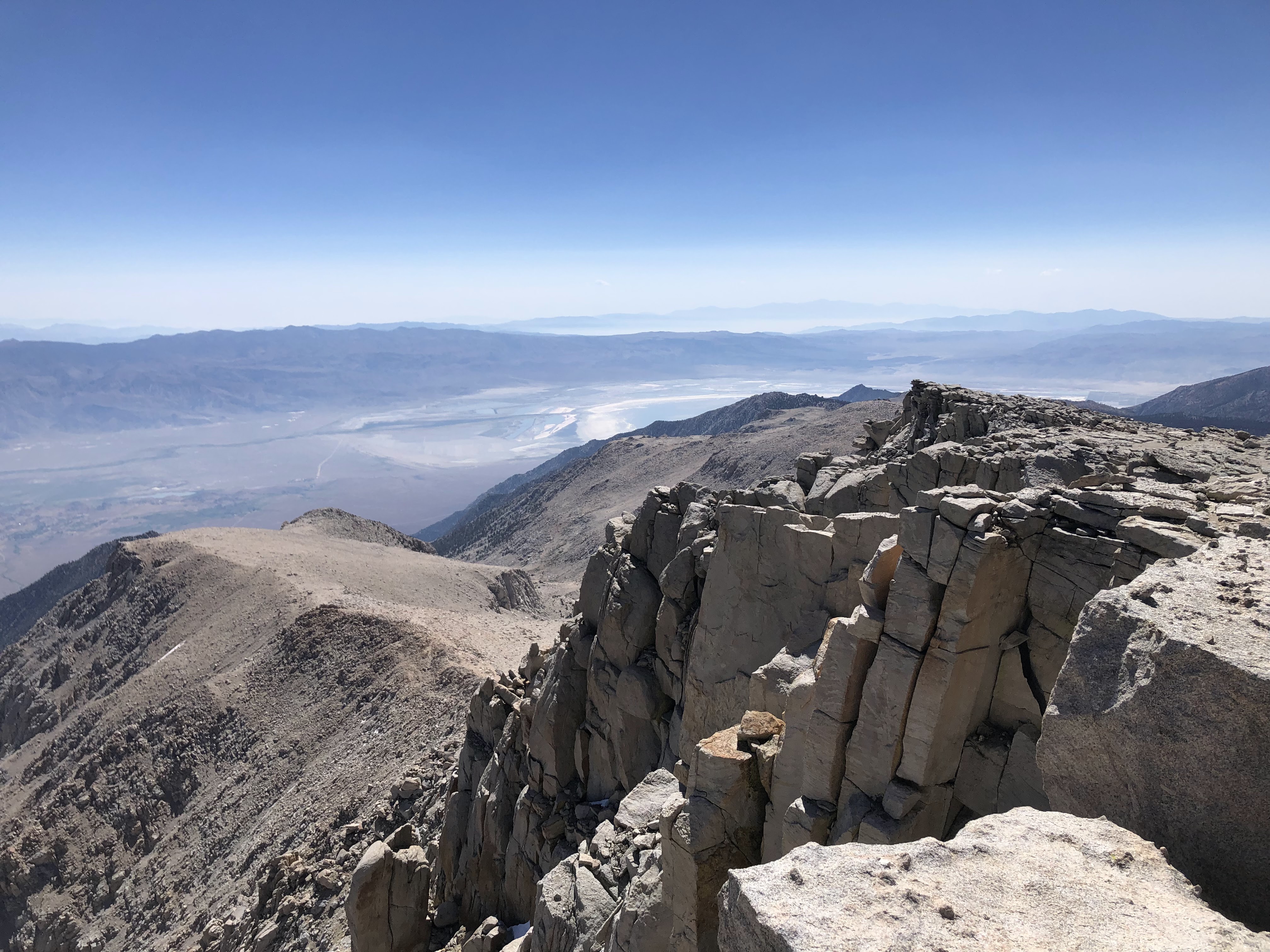
I managed to reach the summit in under 5 hours. There were two others up there. They thought I was Mormon what with my attire and all. We laughed a bit over that one. I sat down and took out my sandwich and checked out the view. There were cliffs all around the northern side of the summit, dropping 2,000ft down into Tuttle Creek. I could make out most of the major mountains to the north, including Whitney, Muir, Russell, Williamson, Lone Pine Peak, and Mt LeConte. I could even make out Middle Palisade and Split Mountain in the distance, looking remote and intimidating. To the east I could see the town of Lone Pine, appearing as smattering of green in an otherwise greenless valley. To the west were views of the Great Western Divide, an area of which I have hardly any knowledge. And to the south were views of pine forests, scattered peaks, and a large plume of smoke heading directly my way. The winds had changed and were blowing north, pushing the smoke from the south back to where it was yesterday. Olancha Peak, which was clear that morning, was starting to get overtaken by the smoky haze.
 |
| Southeast(ish) |
 |
| Tuttle Creek and Lone Pine |
 |
| Northwest(ish) |


A few more people joined us on the summit: the two young guys (who I had passed again on the way up), a talkative woman, and a quiet older guy in a white sun shirt. I didn't spend too long up there; I wanted to beat the smoke on the way down. The wind was increasing in intensity with every passing moment. I took in the views one last time, soaked up the aura of the summit, and then hauled ass down the mountain.

I made excellent time on the way down. I stuck to the use trail, following the cairns as if they were points in a connect the dots puzzle. I figured it would be easier sticking to the trail than down climbing the boulders. I boot skied though some of the gravel, grateful that I didn't have to climb up that nonsense. I reached a less sandy spot and emptied my shoes of rocks and sediment, and then jogged a good ways back to the junction with Old Army Pass. Clouds were starting to form overhead, casting large shadows over the vast expanse of sunlit granite.

 |
| Joe Devel Peak, awash in sunlight |
The French Ladies lied. There was a large snow drift covering the trail near the top of the pass. But no worries. It was easily bypassed. In fact, the entire pass wasn't that bad at all. Only a few parts were washed out, requiring some very easy scrambling. Granted, there was a pretty large drop off to my left but I didn't pay it much attention. Cottonwood lake #4 sat far below, encircled by an impressive cirque of which I was currently descending. Cottonwood lake #5 sat a little farther off, separated from the former lake by a narrow stretch of land. The two lakes looked like a pair of giant blue lungs.
There was a father/son duo climbing up the pass. I informed them of the snow situation, and then carried on. I got down the pass without issue. It looks way more intimidating than it is. It's short, steep, and totally worth it. If I summit Langley again I'll definitely take this route on the way up instead.

 |
| Old Army Pass center right |
I chilled my legs in the bone chilling water of Cottonwood Lake #4. I was gonna go for a full dunk, but chickened out last minute. The wind was now ripping in steady gusts, and I figured that it wouldn't feel too good getting out of an ice cold lake with it blowing like that. Sitting on the shore, I could see wisps of smoke intermingling with the clouds in the sky. Oh well. Looks like it finally caught me. I gathered my things and set off on what would be the most scenic part of the day.
 |
| Tail ends of Cottonwood lakes 4 (right) and 5 (left) |

 |
| Cottonwood Lake #3 |
Each lake was spectacular. The waters were crystal clear, casting the reflections of clouds and the trees. Hardly anyone else was there in the basin; I practically had the whole thing to myself. I met with an older woman who was sitting near the north shore of Cottonwood Lake #3. We chatted a bit, each one describing what the other's day had been like. She was the last person I saw for a while. I walked through the basin, now back in a small pine forest. The smoke was getting thicker and thicker, but I didn't really mind. I was cruisin' down the trail, admiring the stunning scenery of forest, lake and meadow. As I walked along the shore of an unnamed lake I stopped and turned around, looking at Langley for one last time. It was starting to become enveloped in a thin sheet of smoke. Brother, I would NOT want to be up there right now. Altitude is one thing, but altitude+smoke is absolutely diabolical. I counted my blessings and kept on truckin'.

 |
| Cirque Peak and company, lookin' smoky |
The trail down to the fork with the New Army Pass trail was fairly steep, well marked, and smoky. I passed by a few miserable looking backpackers every once in a while. I eventually reached the fork and took one last break, finishing the rest of my sandwich that I started eating on the summit. I was beginning to feel the tell tale signs of an ensuing massive bowel movement, but I decided to take a gamble and see if I could make it to the pit toilets at the parking lot. It would be about an hour of walking, but I figured I could make it.
Oh boy. Those last few miles were very intense. I speed walked through the pine forest, a man on a mission. I left the John Muir Wilderness, crossed a few creeks, and passed several more day hikers and backpackers, some of whom were very young children with packs that looked way to big for them. My trekking poles became a second pair of legs as I kicked it into overdrive to make it to those pit toilets. Sure I could have pulled off the trail at any time. I had the good ol' TP and trowel neatly tucked away in my pack. But I wanted to test my limits, see what I was made of, take myself right to the edge and peek into the unknown. About a mile away, there was serious doubt. A half mile, and I thought for sure I was a gonner. But somehow, by some miracle, I made it back to those pit toilets just in the nick of time.
After nearly detonating the toilet with shear explosive force, I stretched my legs a bit and prepared for the long drive back. The smoke was just as thick as it was the night before, with tiny little pieces of ash falling like snow every now and then. An electric car dropped off two middle aged men and they remarked how much it "really smells like campfire." I started the car, waited for the engine to warm up, and then was on my way.
Langley had proven to be an incredibly scenic peak with an even more scenic approach. Marmots, wildflowers, lakes, cliffs, and meadows. It was an incredible day. Couldn't have asked for anything more.

Well written and a bit of humor.
ReplyDelete