Sunday, December 31, 2023

Year in Review 2023


The year started with big storms and ended with big waves, each event serving as the bookends for a story of unusual mediocrity. Yup, 2023 was a goober of a year. Better than some, worse than others. And though I've tended to view the year through the lenses of pessimism, looking back I am unable to ignore the sparkles of absolute gold. Through the haze of indifference shine unforgettable memories, and it is these memories that defined much the year for me.


The January storms set the mood for the year. With the surplus of water came a surplus of life. The local country seemed to be beaming with energy. Green hills, blooming flowers, full creeks. There was snow on the mountains well into April, and spring seemed to last well into June. It was during this time where I finally managed to graduate college, the results of which caused a healthy degree of burnout and the reason as to why I wrote about half as many blog posts this year compared to last. 

Almost immediately after graduating, Liam and I embarked on the second excursion to Billings. This one was much different than the first, which was done in March of last year. We began the trip with a visit to Zion, a place I try to see at least once every year. It was busy. Seems to get busier every year. But the place is straight magical and even a few hours spent within the park are enough to change one's mood for the better. 


From there we trucked onward to Billings. There was a lot more snow this year. It was late May and some of the roads into the mountains were still closed to the public. Skiing was still in season. I recall a drive into the mountains. We woke up early that morning after nearly staying up all night. Long drive. Backcountry roads. Snow on the peaks, lakes frozen over. Cold air that bit the face and wind that smacked the ears. We got out and walked in the snow in jeans and sneakers. Nearly fell through the ice of some hidden underground stream. It was a good time up there, Tom Petty and Nick Shoulders providing much of the soundtrack for the journey. 


Continuing with the theme of travel, in late June the fam and I made a drive out to Tennessee to visit the Grandparents. All I can say is gee, this country is BIG. And a whole lot of it is just empty. Flat, empty plains stretching for miles and miles and miles. They say that Montana is big sky country but I beg to differ. The Texas panhandle and much of the western part of Oklahoma is a world divided by one horizon: beneath it is the flat empty ground and above it is the flat empty sky. Having never been past the 100th meridian, it was interesting to see the vast differences between the topography of the west and the east. Tennessee possessed a laid back sort of charm, the rolling forest covered hills of Appalachia emitting an essence of a long lost time. Those mountains are old. Real old. Lot of geologic history in them. 

While we were there we made sure to see all the main sights. Went to the Smokies. Climbed Clingmans Dome. Avoided Dollywood at all costs. Stuff like that. On the way back we saw the Bass Pro Shop Pyramid in Memphis. I suppose this is a theme now. Last year I saw the Long Beach Pyramid. Now this. What's up with that? I don't know. 

Somewhere in Oklahoma

Hey look! Another pyramid

After Tennessee came a few concerts. Ain't never been to a concert before. Thought I'd give it a go this year. Saw Ween three times. Saw the Flaming Lips once. All of 'em were excellent. Being part of an audience is a unique experience. The audience becomes an organism of sorts, with you being a cell that makes up that organism. Weird stuff. Definitely gonna go to more concerts in the future.

Fox Theater

The Flips

In November of this year I went on a plane for the first time in nearly a decade. Flew out to Tennessee again to celebrate Thanksgiving. Driving would take too long so we flew. The change in scenery from summer to winter was a head trip. Out here in California we don't really get that many major fluctuations in weather. Out there, what was once a lush forest of bright brilliant green was a dead, gray, cold and rainy landscape that evoked feelings of uneasiness. I can see why those hills are a hub for unexplained sightings and disappearances. In the summer, they're great. In the winter, they're the the spookiest things I've ever seen. Wouldn't want to go wandering into those woods at night that's for sure. 

Margarette Falls in the summer

Margarette Falls in the winter

The Grand Canyon

And that pretty much sums up the year. Got a new job, made some new acquaintances, played some airsoft, stopped and smelled roses, stuff like that. Now that the 33 is open I'm gonna try and head up there as often as I can. Got a lot of adventures planned. Next year is gonna be a busy one. 

Omne Finis Novum Initium Est

Saturday, December 30, 2023

Slide Mountain Lookout

 12/17/23


The wind ripped through the canyon. A few folks were mingling around the gate, mostly fishermen. A few stumbled onwards towards the campgrounds at Frenchman's Flat. All were dressed in large jackets or windbreakers. It wasn't that cold, but the wind always makes things feel worse. We got out of the car, donned the packs, and set off on our journey to Slide Mountain Lookout.

This is one that I probably should have done years ago. I've always seen it from the I-5, nestled on top of a nice looking mountain behind the never empty Pyramid Lake. Swear that thing is always full no matter how dry the weather gets. And the lookout tower just sits there, willy-nilly, overlooking it all. Never thought to explore it. Never even crossed my mind. But I figured it would offer some neat views of Cobblestone Mountain and Cobblestone Mountain is something that's been on my mind recently so I figured I'd give it a go before the year's end.

The Road Walk

A 1.7 mile road walk is required to reach the turnoff for the route to the lookout tower. It's smooth as can be, nearly devoid of potholes. Very easy walking. Grace and I walked head-on into the wind, the canyon acting as a funnel that sucked it in from the north. We saw nobody. Next time it would be wise to bring a bike because for whatever reason time seemed to drag during this part. Though easy, this road walk was incredibly boring, and something that I was not really looking forward to on the way back.

The turnoff

We reached the turnoff and began the slow ascent. The beginning of the route was an old dirt road that appeared to have been graded a few months ago. Eventually this road turned into a well maintained single track. The wind died down as we progressed upwards. Toyan, black sage, and laurel sumac dotted the hillsides, offering a dry and crispy smell to the atmosphere. Much of the toyan was full of bright red berries, which is usual for this time of year. The skies were grey but gave no hint of any coming rain, and the weather was cool and gave no inclination that it would get any cooler. The higher we climbed, the more I thought about bringing a bike for next time. Would be much easier on the way down. Just straight cruisin'. 


The single track led to a ridge where we got our first view of Cobblestone Mountain and Piru Creek. Cobblestone looked cold and distant, despite it having no snow and only being about 5.5 miles away as the crow flies. Piru Creek looked wild and desolate, sharply meandering its way through rugged country all the way to the glistening teardrop of Lake Piru. I'd considered exploring this creek from Frenchman's Flat to Lake Piru as a day hike, but after looking at it from the ridge I've got second thoughts. An overnighter would definitely make things less painful should I ever decide to embark on such an excursion. 

After taking in these views, we continued onward, running into the first people we'd seen on the trail all day. They were two dudes dressed in nylon jackets, wearing baggy pants and carrying two trekking poles each. Both of them seemed to be in their mid 50's and were in good spirits. They warned us that they heard rustling near the summit and thought that it could be a mountain lion. We said we'd keep our eyes open and wished them happy trails. 

Cobblestone Mountain center

Piru Creek

From the ridge, the trail curves east, offering great views of Pyramid Lake. It was here where the wind started to pick up again. From there we curved along the south and then north, ascending the western side. As soon as we hit the western side of the mountain we were back in the full brunt of the wind. With hats fastened and hoods synched, we continued along, the lookout now in sight. 


The summit was empty when we arrived. We walked up to the base of the tower where there was a little metal stand which contained a summit register. We were the 3rd group to summit that day. Strange, since we only saw one other group on the trail. The first group must have done it super early. Morning people. Strange breed those are. 

Slide Mountain Lookout is still in use by volunteers and is therefore in excellent shape. Unlike the rusted skeletal corpse of the Nordhoff Tower or the dilapidated and decomposing Thorn Point, Slide Mountain is fully furnished and weather proof, offering a glimpse of what the towers of yore used to look like. The bottom door was open and swinging in the wind. Inside were a bunch of tools, two big tanks and a festive wreath. After looking in there we closed the door and headed upstairs.


Upstairs nobody was home, but the door was unlocked so we took a peak inside. The anemometer on the wall read a windspeed of 23mph. The digital clock in the corner was 2 hours ahead. The bed was folded nicely and a Smokey Bear hand puppet was hanging on the wall, along with a Condor plushie. The oven was full of old dusty boots. On one of the shelves sat a number of binders and booklets and what have you, each of them serving a specific purpose for the tower. I found a binder full of lookout reports and took a gander at a few of them, interested to see what it was like to volunteer at such a place. Seems like it's windy, according to most reports. Other than that it doesn't seem like all that much goes on up there. In one of the reports, though, a volunteer claimed to have found a perfectly rolled joint beneath the tower. They "got rid of it," never explaining exactly how, but clarified that they did not smoke it. Har, har har...


After taking our little looksie we locked the door and spent a few minutes walking around the outside of the tower. I spent most of them looking to the west at Cobblestone and Dome Mountain, wondering if either of the two could be reached from this location. Cobblestone is likely 100% out of the question but Dome seems feasible. To the southeast could be seen civilization; everywhere else seemed to be desolate, dreary, desaturated and destitute, the I-5 being the only line of connection between one point of society to another somewhere out of sight. Winter lighting provided a calm quietude to the surrounding country that could still be felt despite the ever present sound of rushing wind.  It was relaxing, in a strange wintery kind of way. After having our fill of the views we said our goodbyes to this neat little tower and made our way back down the trail. 


Northwest

Pyramid Lake as viewed from the tower


We zoomed down the trail, I for one wishing that I was on a bike the whole time. On our way down we passed one other hiker and his dog. We hit the dirt road, and soon enough we were back on the asphalt which meant it was time for that darling road walk back to Frenchman's Flat. That road walk went by surprisingly fast but seemed to add a few extra hours to our legs. I don't know if that makes any sense but Grace would know what I mean. Back at the car we talked to a couple of elderly fisherman who asked us where we had gone. After we told them of our travels, they said they had no desire to EVER go up there, no matter how nice it is. And nice it was. With excellent weather, decent mileage, and not much traffic, the hike to Slide Mountain lookout proved to be a good one. 


Thursday, December 14, 2023

Chief Peak and Twin Peaks Loop


I've been putting this one off for a while. Wanted to try this route back in October but just never got around to it. Told myself I'd do it next month. And then November rolled on by and I still hadn't done it. The mountain was only getting taller and the brush only growing thicker. Along came December and I knew if I didn't do it soon I'd likely never do it at all. Just needed to get out there and giver 'er a go. 

The route sounds simple enough: climb Chief Peak by way of Horn Canyon, descending the southern ridge to Twin Peaks, and then taking the trail from Twin Peaks back to Horn Canyon for a nice little loop. I had no idea how long this loop would be, how much elevation gain there would be, or how much brush there would be on the southern ridge. Six years after the Thomas Fire and the brush in the front country has made an astounding comeback. A few years ago, this loop would be fairly simple. But now, with all of this growth, I expected a battle. 

So last week, on the 7th, I parked on McAndrew Rd and began the long slog up Horn Canyon. My stomach wasn't feeling all that good on account of eating a spicy meal the previous night. Pro tip: if you're ever going on a long hike DON'T EAT SPICY FOOD the night before. Just don't. I should of known better but oh well. 

There was still a decent flow in the creek, despite it being covered with dried and stinking algae. Every so often I'd see a good sized pool along the trail that was algae free. I meandered my way through the canyon, dreading the inevitable switchbacks up to the Pines Camp. It was cool in the canyon and there wasn't a cloud in the sky. It was looking to be a great day weather-wise. Just before the start of the switchbacks I nabbed a few sycamore leaves and stuffed them in my pack. Given how my stomach situation wasn't improving in the slightest I figured I'd need these leaves later. 

The section of trail between the canyon floor and the Pines Camp just plain sucks. There's significant elevation gain with little relief, and the trail just keeps going and going. By the time I got to the Pines Camp I was honestly pretty beat and had exhausted most of my supply of sycamore leaves. I took a long break before continuing on. 

The Pines Camp

From the Pines Camp to Sisar Rd I simply moseyed along at a relaxed pace, taking several micro breaks in the process. This section of trail has gotten some attention and is in excellent shape. I can only imagine how miserable it must have been hauling up all the gear for this trail work. I give my thanks to whoever worked on this trail; it looks really, really good. 

When I got to Sisar Rd I plopped down in what shade I could find and took a little breather. I noticed two people walking up Sisar to the ridge road. Aside from a guy I saw near the horse corral by Thacher, these two were the only people I saw all day. I caught up to them at the ridge road junction and saw that they were making their way toward Red Reef. It appeared that I would have Chief Peak all to myself.

I walked along the ridge road to the turn off for Chief Peak. Unlike last year, there was hardly a cloud in the sky and had no trouble following the use trail all the way to the summit. 

Chief Peak

I spent a good half hour recuperating on the summit. A few crows were flying overhead and every now and then I'd hear the screech of a hawk somewhere in the distance. What I found most interesting, though, was that I could actually make out the sounds of civilization coming from Ojai and its surrounding communities. It was so quiet on the summit—no wind, no nothing—that I could actually make out the sounds of construction and sirens, not to mention the ever present steady hum of traffic. It was a little weird. Just goes to show just how far noise can travel. 


From the summit I was gifted full view of what needed to be done, that being the ridge descent to Twin Peaks. To the south I could see most of the ridge descent as well as the little knob that marked the summit. I knew that by going down this ridge I'd be saving myself from excess mileage, but the brush situation was still a mystery. If the brush was more than waist high it could possibly take me a few hours of bushwhacking to traverse this ridge, and since it was getting later in the day and because I didn't think to bring a headlamp, I could be ending this hike in the dark. 

Not wanting to lose any more daylight I said goodbye to Chief Peak and skipped my way down to the ridge road. I hit the ridge road in what seemed like no time and jogged the rest of the way to the turn off for the southern ridge. I left the road and walked up the ridge, the first section being mostly clear of brush. I crested a small rise and was gifted a view of the bushwhack to come. I turned around, took one last picture of Chief Peak, and then began the brushy descent.

Chief Peak as viewed from the top of the ridge

The southern ridge

To my surprise, the brush at the top of the ridge was not bad at all. Chamise, yerba santa, and tiny little bunches of manzanita were easily avoided. I followed animal trails when I could, and now and then I'd find a long rut that was totally clear of brush. If the rest of the ridge was like this, it would take no time at all to reach Twin Peaks!

Alas, this was not to be. I soon discovered that most of this ridge consisted of fairly thick, waist high brush. Brush of all kinds. Soft brush, hard brush, wispy brush, prickly brush. This ridge has it all. None of it was impenetrable, and there were only a few spots where it rose above my head. Using mostly my shins, with the assistance of gravity, I busted my way bit by bit, breaking my own trail as I went. Sometimes I'd hit a clearing, sometimes I'd find an animal trail, but for the most part it was a waist high wall of sticks. Skeleton arms of shrubs long dead and blackened by fire poked hither and thither from the green carpet of brush, poking and prodding me as I tore my way down the ridge. I was half expecting one of these skeleton arms to poke me right in the crotch, and as soon as this notion came into my head one of them stabbed my inner thigh. It was like the brush could read my thoughts. From then on I was more careful of where I tread. I was light on my feet, moving like water, trying to find the path of least resistance. 


I got used to the brush fairly quickly. Waist high brush ain't much of a big deal. I could see my destination and it was getting closer by the minute. Within an hour of starting this descent I was standing on the summit of Twin Peaks. The ridge looks very intimidating looking back at Chief Peak from the summit, but it was honestly not nearly as bad as I thought it would be. In a few years, this ridge descent will be a hell of a challenge and in a few decades (if there aren't any more fires) it will be damn near impossible. But for now it's highly doable and something that I will likely do again in the future; it's a fun little detour that's worth notice. 

The ridge and Chief Peak from Twin Peaks summit

There's a new summit register that was placed in February of this year. Most of the entries were from Thacher students. One person claimed to have spent the night on the summit in a bivy. That sounds like a cool idea. The views from the summit are pretty good and at night it would be neat to see the layout of the city. I signed my name, drank the last of my water, and then suddenly remembered to check for ticks. Even though they shouldn't really be out this time of year, I figured it wouldn't hurt to look. And wouldn't you know, I found two of the little buggers on the inside of my right pant leg. 


Twin Peaks summit, Chief Peak left

Twin Peaks

As I left the summit of Twin Peaks, I quickly learned that the trail was not in the best condition. A lot of it near the summit was overgrown and a few spots will likely be wiped out during the next rains. I counted six ticks by the time I made it out of the brushier section, two more by the time I made it back to Horn Canyon. Seems like most people stick to the lower part of the Twin Peaks trail as I saw multiple bootprints and bicycle tracks nearer to the junction with Horn Canyon

I got back to McAndrew Rd with daylight to spare. Loop complete, I felt a sense of accomplishment. Don't know why I put this one off for so long because it turned out to be a pretty cool adventure. The weather was great, never saw no snakes, and most of the day was spent in solitude. The only thing I'd do differently next time is eat a MILD dinner the night before. Ain't never repeating that mistake again...


Saturday, September 30, 2023

September in the Sierra

Mt. Gould


September is usually the best time of year to visit the Sierra. Weather ain't too cold, snow ain't too high. Wanted to get at it while the goin' was good so on the 7th Grace and I took a little trip up to Kearsarge Pass. We drove up the 395 the day prior, noticing the major construction being done on several parts of the highway. Pulled up to the parking lot at Onion Valley and slept the whole night through. We were lucky to find a parking spot there; on the way up we saw several cars parked along the side of the road leading into the lot.

We woke up the next morning just as the sun was cresting the Inyo Mountains to the east. Little bits of early morning light could be seen reflecting off the tippy tops of the high peaks. We gobbled down some energy bars, put on the layers, and headed out on the pleasantly graded trail. As we moseyed on up the trail we saw the light percolate down the sides of the mountains, painting the valley with a delicate, golden radiance.


We took our time, running into the occasional hiker who was walking down the trail back to civilization. We walked by Little Pothole Lake, Gilbert Lake, Flower Lake. Not a lot of people were out and about which was a surprise to me. Given the popularity of the trail, I was expecting a whole lot of traffic. 

We made it to the switchbacks that pass above the aptly named Heart Lake and after surpassing those we caught our first glimpse of Kearsarge Pass and Mount Gould. I mentioned to Grace that if we felt good at the Pass then maybe we could take a shot at climbing Mount Gould since it's basically right next to it. Mount Gould was not in the schedule but the day was looking to be a good one and there wasn't a single cloud in the sky so might as well climb it, you know? On our way up the final switchbacks to the Pass we were gifted with fantastic views of Big Pothole Lake, which was mostly frozen over. I'll admit that a part of me wanted to boot ski down the slope to the lake and goof around on the ice...but I thought better. We made it to the Pass, stopping to chat with a handful of JMTer's who were heading into town. One of them was wearing these 2inch synthetic neon shorts with ducks on em. We complimented his shorts and he was very grateful. 

We took a ten minute break. I asked Grace if she felt good and she said yes and I asked if she wanted to climb Gould and she said yes and then I said something like "okay!" and we started the climb. I had summited Gould the previous year with Liam and had learned that it's actually a pretty straightforward climb. There's a well defined use trail from the Pass that leads all the way to the summit block, which requires a class three move. It's an easy peak to climb for the inexperienced, which is great because inexperienced is my middle name. 

Climbing Gould, University Peak in the background

It was a lot easier climbing Gould this time around, probably because we took our time. The altitude was definitely present but it never made us feel queasy or dizzy or whatnot. We took a lot of breaks, stopping to take in the incredible views of the Owens Valley to the east and the Great Western Divide to the west. We made it to the bottom of the false summit and took one last break before the final bit of the climb. Grace decided to call it quits there. I told her that the true summit was quite literally just behind the false summit, barely even 200 meters away. She said she was good and that ending there was just fine with her so I said something like "okay!" and continued on my merry way. I weaved around the false summit and got my first good view of Gould.

Mt Gould

I stuck to the left of the summit and then turned right and carefully scrambled up the class three blocks to the top. I signed the register, noticing that a lot of people who climb this peak do it in tandem with Dragon Peak which lays a little ways to the north. Ain't no way am I doing that, at least for a while. The route to Dragon Peak from the summit of Gould looks extremely intimidating. No thank you. Imma stick to the easy stuff for now. 


I didn't stay too long on the summit. I climbed back down, met up with Grace and then the two of us kinda just sauntered back down to Kearsarge Pass. Going down Gould was much easier than going up, and as soon as we hit the pass it was smooth sailing all the way back to the parking lot. We saw a lot more people as we walked down the trail. Seemed like a lot of people enjoyed getting a late start that day. We made it to the car and then hit the road back home. It was an absolutely fantastic day. Always great to accomplish more than what you originally set out to do. 

Big Pothole Lake


Cirque Peak and Environs


A week after climbing Gould, on the 14th, I asked Grace if she wanted to join me on an adventure up to Cirque Peak. She told me that she had got her fill of the high Sierra so I said something like "okay!" and went at it alone, driving up the 395 to Horseshoe Meadow in solitude. Like Onion Valley, this parking lot was also quite full but I luckily managed to nab a spot a few feet from the trailhead. 

It was freezin' in the morning. I waited until the sun had risen a little bit before heading out. All was quiet in the parking lot, not a soul was about.  I geared up and race walked down the trail, trying to get the blood pumping. At the meadow I heard a pack of coyotes yipping and yowling some ways off. I never saw them. In fact, I saw nothing that morning. No animals, no people. It was just quiet, cold walking. The switchbacks up to Cottonwood Pass helped warm me up a bit and before long I was at the top of the Pass shedding layers and preparing to climb the first peak of the day: Trailmaster Peak. 

Cottonwood Pass

Trailmaster Peak, from Cottonwood Pass

After taking a short breather at the Pass I continued along the trail. Not too much later I left the trail and started zig zaggin' up to the peak. I never found a use trail but there were a few cairns that I assumed marked the "easiest" way to the summit. Frankly, every possible route looked the same, all of it being class one. I thought the cairns unnecessary as it was quite obvious, even to a dullard like me, where to proceed. I trucked on up through the boulders and eventually gained the summit ridge. 


Chicken Spring Lake

From the summit ridge I was gifted with a nice view of Chicken Spring Lake, which looked a lot more full than when I saw it last year. I saw two little neon tents near the camping area by the lake. No one was out and about. I followed the rocky ridge the rest of the way to the summit, sometimes straying to the right when things got a little too spicy. 

The Summit

Horseshoe Meadow and such

On the summit

I never found a register at the top but, then again, I wasn't lookin' for one. Trailmaster Peak was a bonus for the day as the main objective was Cirque Peak, which was clearly visible from the summit. It was a tad chilly at the top so I put on the ol' sweater and made my way off the summit towards Cirque Peak. 

Cirque Peak on the right

The walk from Trailmaster to Cirque was surprisingly pleasant as I soon discovered that it was relatively flat. I would say that it was kind of like walking on the moon given how empty and rocky and dry the terrain was but I won't. Why? I saw a few yellow and pink flowers hiding in the cracks between the rocks and last time I checked there are no flowers on the moon so making the comparison is quiet silly, you know? Plus I was breathin' just fine and I know there ain't no oxygen on the moon either so there you go. I walked around peak 12525 and got a good look at Cirque, scanning the south face for the easiest route to the summit. 

Walking on the moon

Cirque Peak, Mt. Langley to the right

I made it to the base of the summit and felt a little disheartened as I looked up at the peak. It looked steeper than a bill at a fancy restaurant. I took a break, drank some water, and began the inevitable slog. Walking up this peak was about as hard as walking up the final rock hop of Whitney in terms of aerobic exertion, despite the fact that this peak is several thousand feet lower in elevation. I was huffin' and puffin', feeling like I was sprinting at full speed even though I was just walking. But no matter. Like I always say, puttin' one foot in front of the other got me to the summit sooner enough. 


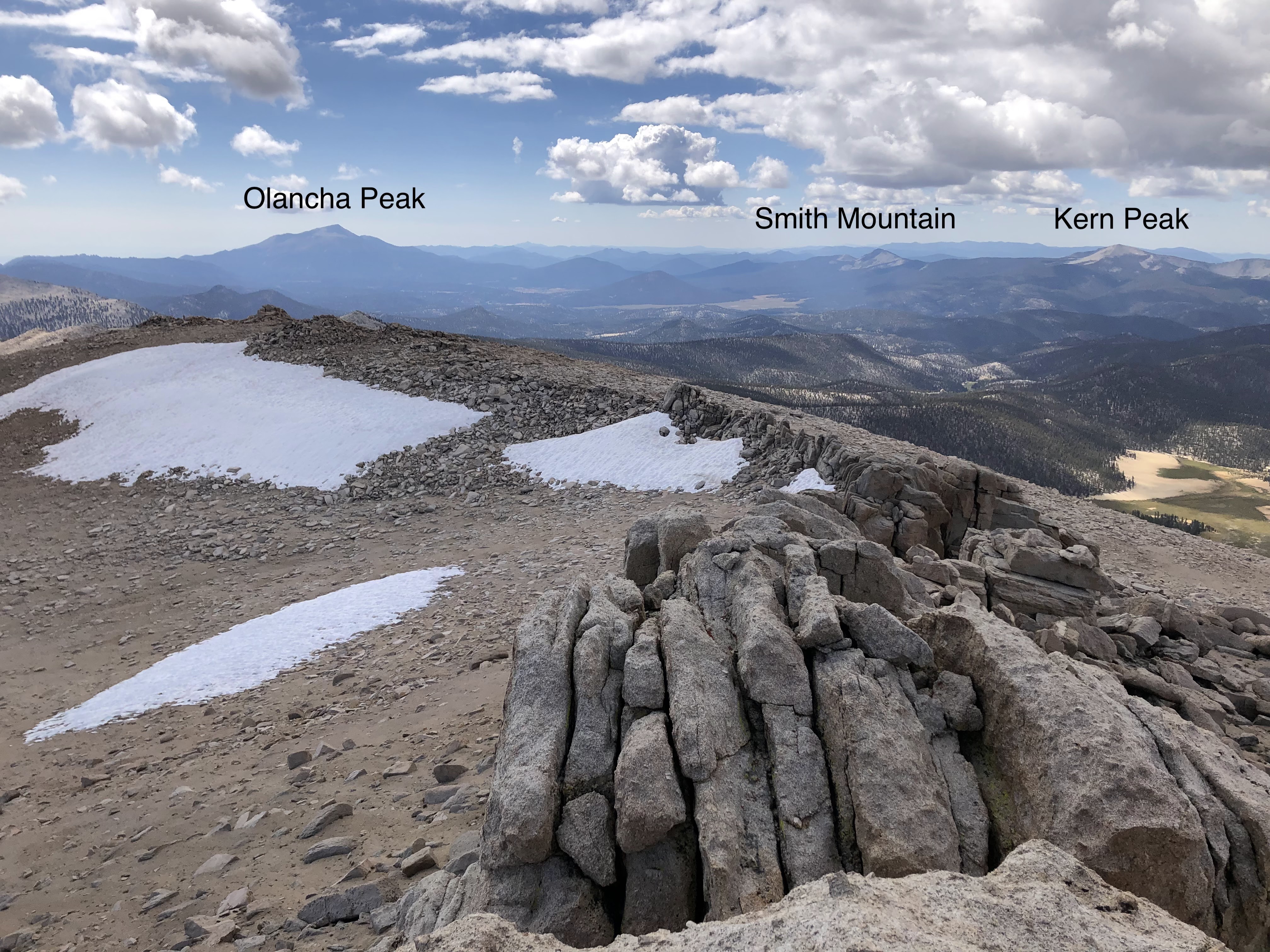
I found the register and signed my name. I discovered that this was a fairly popular peak; the last person summited just two days prior. I hung around at the top for a little bit, enjoying the views of Mount Langley and Mount McAdie to the North, the Kaweahs to the west, Olancha Peak to the south, the several Cottonwood Lakes and Owens Valley to the east. I could not see the summit of Whitney as it was obscured in clouds. 

View West(ish)

View East

View North

I hung around for a bit until it started getting cloudy and cold and then I knew that it was time to go. On my way back towards Chicken Spring I decided to take a different route, this time moving around Peak 12525 to the west. This would create a bit of a loop and would save me the trouble of navigating around Trailmaster Peak. 

Heading back, view South(ish)


As I was walking along I looked up at Peak 12525 and debated whether or not I should climb it. It was, after all, "right there!" and after thinking it over I said something like "okay!" (despite the fact that no one was around to hear it) and made for the summit.

Peak 12525

The going was easy until it wasn't. The summit blocks were particularly tricky and after scoping around for a bit it seemed like there was nothing easier than class 5 up to the summit. I picked the easiest looking group of boulders with the least amount of exposure and cautiously made my way to the top. When I got to the top I realized that I wasn't actually on the true summit, which was about 50ft to the north. I could of rock hopped over there but that was a bit too sketchy for my taste. I stayed were I was, enjoying the same views that I'd seen all day. 


I made it off Peak 12525 without issue. The area around the peak has some very interesting rock formations so I took a little time to explore and goof around. After having my fill I steadied my course and made a bee line to Chicken Spring.


Chicken Spring Lake, Trailmaster Peak on the left

I found a descent chute that looked like it dumped out on Chicken Spring so I boot skied down that and I was on my way. I walked around the east side of the lake, trying to remember where the water level was last year. I noticed some boulders that I recall leaning on that were almost completely submerged in water. I poked around the camping areas and found nobody. The two neon tents that I had spotted that morning were gone. I hadn't seen anyone all day, which was surprising given the popularity of the area. 

The Chute


I left the lake and hit the PCT and from there it was smooth sailing all the way back to the parking lot. As soon as I got back on the trail I saw people. Then I saw more people. Then I saw a whole group of people wheezing their way up the switchbacks to Cottonwood Pass. Like Onion Valley, it appeared that people enjoyed getting a late start that day. 

The PCT

I made it back to the parking lot in good time. On the drive back I stopped along the road and kinda just sat and stared at Owens Lake for a while. I ain't never seen it full, and I'm fairly sure that most people (before the biblical rains earlier this year) have seen it full either. When Grace and I drove back from Onion Valley we saw it along the side of the highway but couldn't take in the scale. But sitting on road, way up in the mountains, I could see the lake in its entirety, just one big turquoise reflecting pool. It was a neat way to end a neat trip, and I couldn't have asked for better weather. September in the Sierra. There ain't nothin' like it.