Sunday, March 31, 2024

A Day at Pinnacles National Park

03/27/24


Fog defined the morning. It soaked everything, spilling over the land with the viscosity of a chowder that's been left in the sun too long. We drove up the 101, northbound, until reaching King City. There, we stopped at a little gas station to load up on some grub. I purchased myself a burrito. It was pipin' hot. Nearly burnt my fingers off just touching it. But it was good and gave me the nutrients that I needed. Sometimes gas station burritos are the best form of fuel, able to quell crippling hunger and offer enough energy to put a double espresso shot to shame. Other times they give you nothing but severe bowel trouble. It's a gamble for sure, but totally worth it. Them things is tasty! 

We left King City in search of the 25, which would take us to the junction with the 146 which would lead us to the east entrance of Pinnacles National Park. I had low expectations. Grace had been wanting to see the park for some time and had invited me to come along. I ain't never been before, but I had a good idea of what to expect. Lots of pointy rocks, spread around on some hills, reaching high into the sky. Wildflowers. Animals. People hiking with wayyy too much sunscreen. That sort of stuff. 

We drove into the hills, escaping the clutches of the fog. Before long we arrived at the park and drove straight to the Bear Gulch Nature Center, hoping to nab a spot before it got too busy. The nature center itself was closed, but the lot right next to it served as a starting point for one of the most popular loop hikes of the park. 

We started our day hiking up the Condor Gulch trail. Several people were hanging around the trailhead, using the bathroom and taking off jackets and putting them back on and securing their packs and such. Oddly enough, there actually weren't that many people out on the trail. On our way up, we saw a team of folks all wearing condor shirts and carrying radios and heavy packs making their way down the trail back to the parking lot. A few families were out and about, along with a few elderly folks hiking in groups of three or four. We moseyed up the trail, slowly gaining elevation until we reached a ridge of sorts that gave us some nice views of the namesake pinnacles for which the park is named. 

Condor Gulch Trail

The Pinnacles

Sooner or later we reached the junction with the High Peaks Trail, which would take us up close and personal to the pinnacles. I will say that "pinnacles" might be a bit of a misnomer. Sure there were some fingers and spires of rock jutting up towards the sky, but most of the rocks were all fused together, like fingers tightly pressed up against one another. These pinnacles weren't done yet; looked like they needed to marinate a few more million years before they'd be ready. Labeling aside, they were still very cool. Kinda reminded me of Sandstone Peak area in the Santa Monica Mountains. 


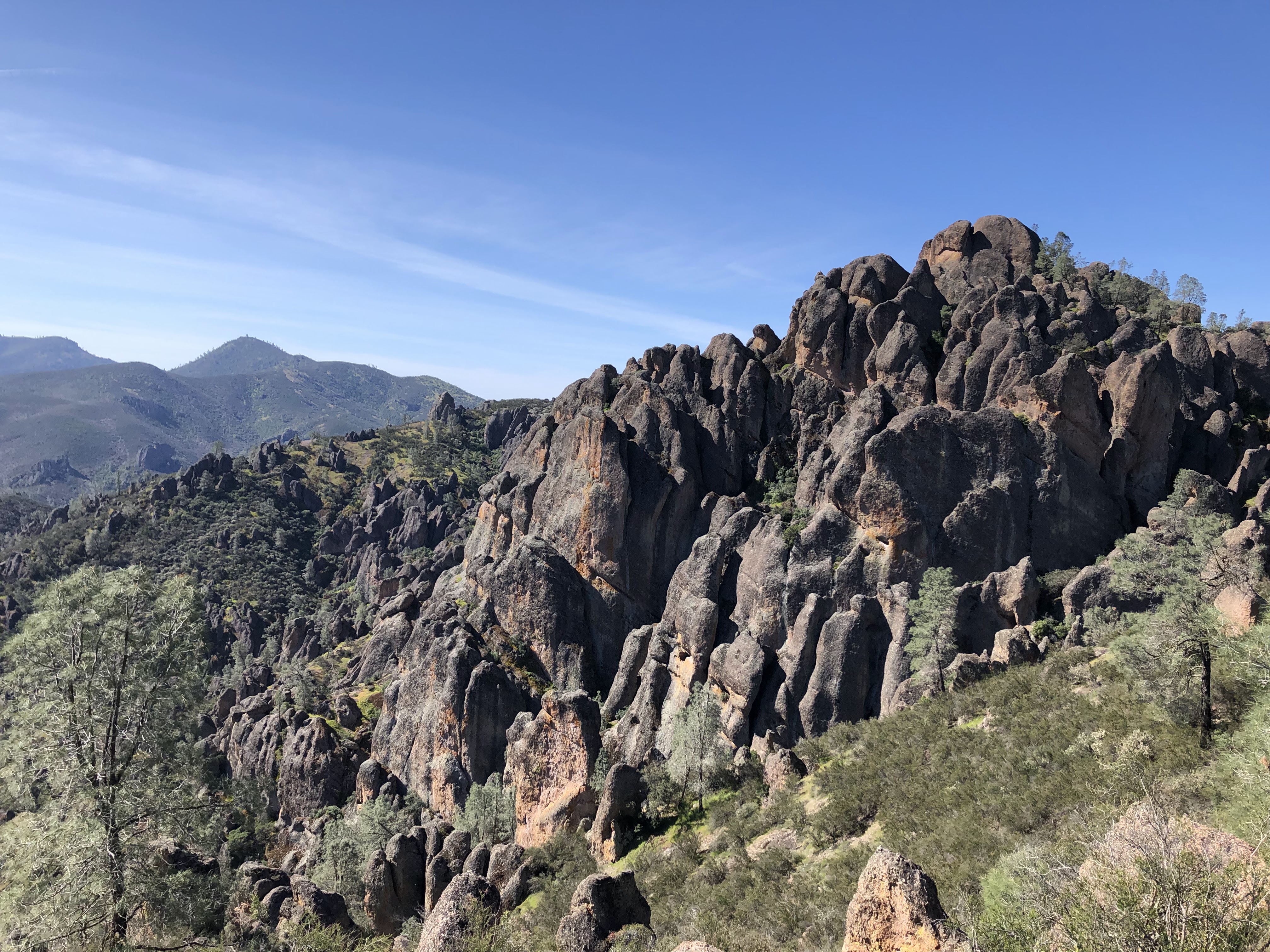
The High Peaks Trail wound its way through the formations, well marked and well traveled. As we progressed it was as if we were being transported into a forest made of stone. Huge pillars and slabs of rock lined the trail, some of them covered in colorful lichen and moss. In the shadier sections we found lots of miner's lettuce and ferns and super soft grass. It was a very interesting trail, one that I'm sure was quite difficult to create. In one section, the trail fused with a large formation, stone steps carved into the rock and a handrail provided for protection. It was here were we spotted the one and only condor that we would see all day. It swooped right over us, flying low and silent, gliding off towards who knows where. In one second it was there, in another it was gone. Very magnificent bird. I felt grateful and honored to be able to travel through its domain. 


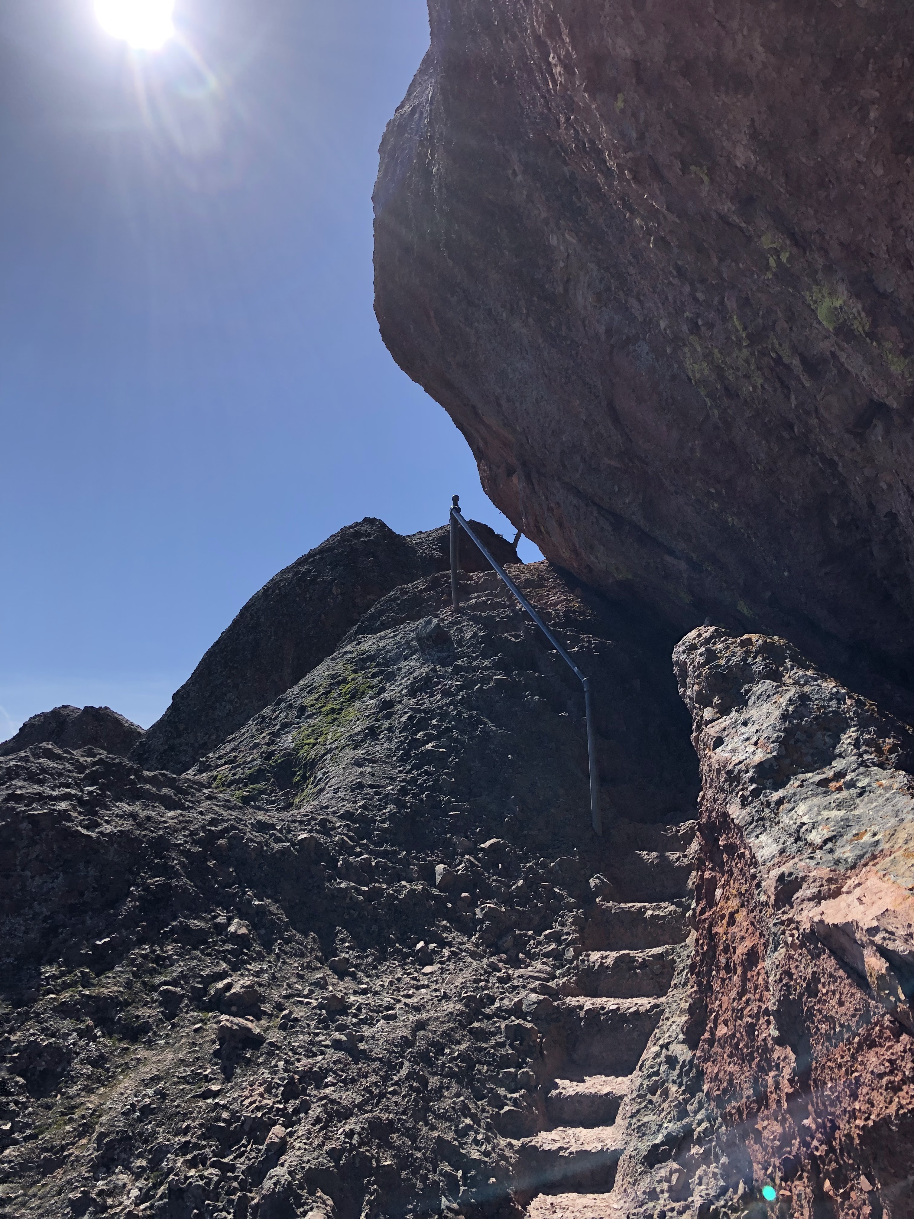
The section with the steps and handrail was super narrow and would only allow one party of hikers to cross at a time. Lucky for us, hardly anyone else was up there. We breezed through this narrow section without any traffic jams. From there the trail lost elevation, dropping down out of the pinnacles towards Bear Gulch Reservoir. Winding in and out between formations, we caught glimpses of the view to the west, noticing that the fog from earlier in the day was busy disintegrating in the face of the bright yellow sun. 


Spring colors seemed to elevate the scenery into something quite astounding. I bet the place is a lot less interesting in the summer when it's 100+ degrees and everything is shriveled, desiccated and dead. Weather-wise it was almost perfect, with several buzzards and ravens and crows and a whole other assortment of flying creatures zooming up above, filling the sky with their varied songs and whistles and calls. Everything, even the rocks themselves, seemed to be pulsing with life. Must have been the color. Everything was hyper-saturated with a brilliant springtime glow. Purples, yellows, oranges, and green. Lots of green. Nearly every shade. As grass it flowed between the pinnacles like a velvet river. As moss it cascaded over the rocks like a waterfall. As trees it clung to the cliffs, outstretched like the tentacles of a hungry anemone waiting for its next meal. Flecks of orange and neon lichen clung to the pinnacles, and several patches of wildflowers lined the trail, small and colorful, awaiting their full bloom in the coming weeks. 


Bear Gulch Reservoir

We took a small break at the reservoir. A few families were scattered around the edges of the water, picnicking and chatting and enjoying the scenery. Some hikers, instead of stopping, continued along the trail, heading for Chalone Peak. I caught several glances of a fire tower situated on the top of the distant peak while on the High Peaks Trail. Looked cool. Definitely gonna save that one for another time. 

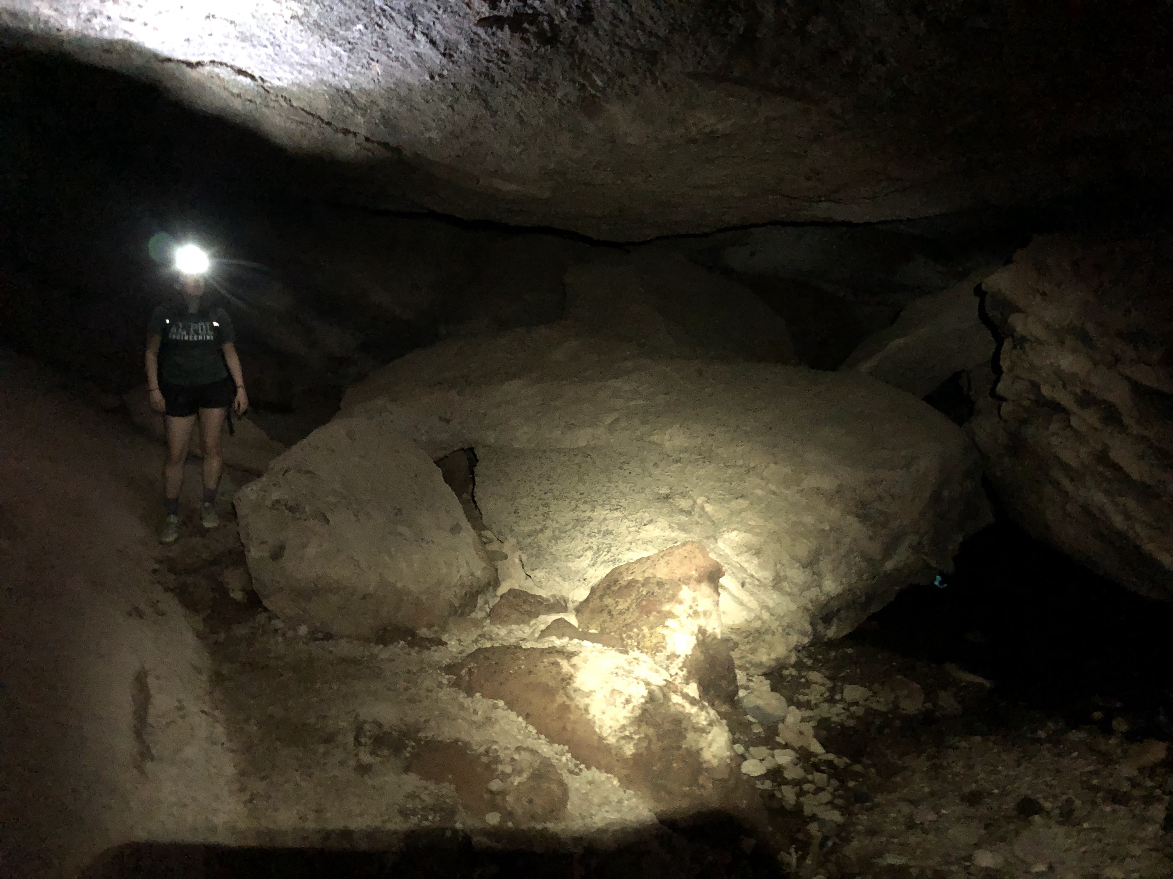
From the reservoir we descended a narrow rock stairway into the depths of a large talus cave. Some people were making their way back up into daylight, all of them with headlamps and shoes soaking wet. We passed a "point of no return" where one could continue along a well maintained trail, avoiding the cave entirely. We chose to stick to the cave. We took out headlamps of our own and entered the darkness. 

We immediately got our feet wet. There was a steady flow of water running through the cave, shin deep in some parts. We ran into one party going the opposite direction, letting them pass first as it was an extra tight section. There was one guy in the group hiking barefoot. Yowch! 

The cave was surprisingly long, filled with chambers ranging in size from phone booths to dance halls. Every so often some light would shine through the cracks in the utterly gargantuan boulders that made up the base, sides and roof of the cave. And the water in which we were traveling broke off into a massive cascading waterfall, dropping several stories down a pitch black chute. We followed this waterfall off to the side, climbing down a series of stairs and bridges. 


We exited the cave and continued with our loop, eventually making it back to the Bear Gulch Nature Center. From there we left the parking lot and drove to the visitor center and the camp store, both contained within the same building. We left the park and made our way to the west entrance, an endeavor that would take us over an hour to complete. There's no road that connects the east and west entrances of the park. Gotta drive all the way back to King City and start all over again. But the drive is quite pleasant; very similar to the scenery you'd find driving on State Route 166. 


As we progressed the crystal blue sky became marred with clouds. Soon the whole sky became swollen with a blanket of grey, stretching as far as we could see. The change was so significant and so fast that it looked and felt like a whole new day. 

The west side had a nicer visitor center than the east, but it was closed. It was a whole lot quieter as well—hardly a soul was there (probably because it was closed, I reckon). We drove all the way to the end of the road, parking at the Balconies Trailhead, bound for the "Balconies Cave." Here we found more people, but not much. Seems like most everybody hangs out on the east side of the park. 

Moss Waterfall


This part of the park had formations very similar to those found at Piedra Blanca in the Sespe Wilderness, but these ones were several times larger. The Balconies and Machete Ridge towered above us, each one several stories tall. Walking along the trail, following the crystal clear creek, it was hard to imagine that we were in central California and not somewhere deep in the wilderness of the Escalante or Zion National Park. Several spur trails marked with carabiner icons branched off the main route, each one leading to a primo climbing spot. What with all the cliffs and spires and boulders, this place is a climbers paradise. 


The canyon narrowed, the moss covered trees disappeared, and soon we were at the mouth of the cave. This one was a whole lot colder than the other. The water running through it must have come directly from the mountain 'cause brother, it was COLD. Felt like needles sticking into our feet. The cave wasn't completely dark until the very end, where it ducked under a huge boulder and descended a slick staircase into a chamber with walls saturated with water. 

Everything in that chamber seemed to be oozing with water. Don't know where it came from. Very confusing. Adding to the confusion, the cave then made a hairpin u-turn to the right, dumping us out into the daylight in a spot that looked much like the entrance. But it wasn't. We were on the other side of the cave, having walked in a straight line from point A to point B. Maybe I wasn't paying attention. Maybe I was distracted. But there's NO WAY we walked in a straight line the whole way. It just doesn't make sense. "Balconies Cave" isn't a proper name. "Cave of Bewilderment" is more fitting. 

The Balconies

Machete Ridge

The cave trail met up with the Balconies Cliffs Trail which we took to get back to the parking lot, making a nice little loop to finish the day. The trail took us up out of the canyon and onto the lower part of the Balconies, offering views of the stunning Machete Ridge and some of the higher pinnacles that we'd visited earlier in the day. We passed a few hikers on their way to the cave, some turning around after learning that there were tight spots and that they needed headlamps and that their feet were definitely 100% gonna get wet. We made it back to the parking lot in what seemed like no time and all, and with that we had completed our day at the park, nothing left on the to-do list except the super long drive back home. 

Though this park lacks the grandeur and scale and beauty of some of the other parks I've visited, it more than makes up for these things with its peace and quiet. It's relaxing, restful, serene; walking through those formations filled me with the same sensation of tranquility and repose that I feel while visiting Pine Mountain Ridge. It absolutely worth a visit if you have the time. I will definitely be back. 


Saturday, March 9, 2024

Water in the Desert

 02/28/24


Hit the road before the sun came up. I was not alone. Early morning commuters jammed the freeway, driving at speeds that I thought were only reserved for night owls. Man those early birds drive fast. Must be that morning coffee that gets them all in a tizzy. 

Merged onto the 126 with all the other speed demons and zoomed on through Santa Paula, Fillmore, Piru. Sun made its welcome just before the junction with the I-5, golden, shimmering and brilliant. Merged onto the I-5 and joined the pulsing superorganism of vehicles that rushed across the pavement like blood cells in vein. Hit the exit for the 14 and settled in for one of the longer portions of the drive.

The 14 undulates and meanders through a country defined by dry chaparral, dust, and a lot of suburban housing before leaving all of that behind for desert, desert and more desert. Palmdale, Lancaster, Rosamond, Mojave and then it's empty for a while, passing the occasional podunk congregation of beat up trailers and sun bleached houses. 

After driving through the desert for a good minute I ditched the 14 in favor of the 178, now in search for a gas station somewhere in Ridgecrest. Drove through Inyokern, the town that famously declares it's "100 Miles From Everywhere" despite the fact that it's only a 12 minute drive from there to Ridgecrest. I guess "100 Miles From Everywhere Except Ridgecrest" would just look too silly to put on a sign. Made it to Ridgecrest without issue, found a gas station, and topped off my tank with 91 Octane that cost exactly as much as the cheap stuff back in Ventura.

I left Ridgecrest, driving in an easterly direction. I saw the tippy top of Telescope Peak poking up from the northeast, easily towering over all of the other desert peaks. Its snow capped summit made it hard to miss. For the first time that day, I was completely alone on the road. I was in real desert now, the kind of desert that's so vast, empty and wide that it can swallow you whole if you're not careful. Every now and then a freak in a luxury vehicle or beat up piece of junk or modded out Jeep would fly past me, likely exceeding speeds over 100mph. Those desert drivers are the fastest there are. They'd beat the morning commuters by a mile.

I wasn't too keen on going fast as I had never been on that section of road before and was much more interested in observing the country at a leisurely pace. I passed by the Trona Pinnacles—little chocolate Hershey's Kisses sprinkled over a dry and desiccated basin. Rounded a corner and I was in the Searles Valley, immediately noticing the steam billowing out of the Searles Valley Minerals factory located in Trona. 

Driving through Trona was like driving through a land frozen in time. It's only one valley over from the infamous Death Valley, separated by the tall and forbidding Panamint Range. Both valleys get stupidly hot. Houses boarded up and abandoned and bleached and broken down. A quiet gas station. A closed drive in. An antique store. Tons of old cars and trucks. Dirt roads. Dust. Because of the mineral content in the soil, along with a lack of water and scorching temperatures, the local high school football field is composed entirely of dirt. Known colloquially as "the pit." The whole town looks like it hasn't changed much since the 40's. Save for the lack of people. The place is practically a ghost town. 

After passing north through Trona I became fully immersed in the vast expanse of undeveloped, unpopulated, unburdened desert. Except for the road and some power lines, there was no other sign of man and his creations. And then I saw it. A glimmer in the sky. A flash, a whoosh, and it was gone. I pulled over the first chance I got, hopped out of the car and waited for it to circle back.

Sure enough, I heard a sonic boom, and suddenly it appeared overhead, a tiny speck in the sky, zooming straight forward before making a hard left to the east and circling back. It did this two or three more times before disappearing completely. It was a fighter jet of some kind, like the ones in those Top Gun movies. Those things move pretty fast, but not as fast as those desert speed junkies. 

Just before reaching the junction with the 190 I got my first look of water in the desert. The usually dry Lake Panamint was like a brown reflection pool, likely containing no more than a few inches of salty water. Some folks, who had seemingly appeared out of nowhere, pulled over as well, enjoying the serene beauty of this ephemeral lake. Telescope Peak rose to the east, Maturango Peak to the west, both of them snow capped and shining and brilliant. Some yellow desert flowers carpeted the landscape, and the numerous creosote bushes and desert holly glowed with a quiet and subdued green, grateful for the surplus of moisture that they had received with these past rains. 

Telescope Peak in the distance

Lake Panamint

I made a right on the 190 and ventured up out of the valley and into the mountains. I reached Towne Pass and could make out Pinto Peak to my right, a smattering of snow covering its summit. From there it was a long descent of roughly 5,000ft into the bowels of the hottest and driest and lowest place in the country: Death Valley.

Mesquite Flat Dunes


Out of curiosity, I decided to walk a bit into the Mesquite Flat Dunes located a little ways past Stovepipe Wells. There were a few people out and about, most of them taking selfies with a dune in the background. The sand looked a lot like that of a beach. It was trampled and beaten and well worn, the result of heavy traffic over the years. I trekked a little farther than I probably should have, shooting for the highest dune in the bunch. Climbing up a sand dune three days after running a half marathon with no training was not the best idea and made my legs very unhappy with the rest of my body. But the view was worth it and the sand was soft and the weather—forgiving. 

With angry legs I got back on the road and made for Badwater Basin. But before I got there, I decided to make my legs even more angry by going on a quick jaunt up Golden Canyon. Saw the sign, saw the cars, looked like a popular spot and I'd never been there before, so I went! There were more people there than at the dunes. A group of cyclists had stopped and were eating their lunch in the shade of the canyon. Some type of school group was huddled in the shade, a few of the children's faces red and miserable. A young couple had ventured off trail and were scrambling on the side of the canyon. Elderly folks with walking sticks and spongy shoes moseyed up the trail, offering a remark every time they saw a cool formation or  a rock or something eye catching. The canyon itself was fairly impressive; reminded me a lot of the terrain in and around Quatal Canyon in the Cuyama Badlands. As for the name "Golden Canyon," I'd say it's a bit of a misnomer. Though the rock was quite gorgeous it wasn't exactly "golden." "Chalky Yellow Canyon" would be more apt.

Golden Canyon


I made it to the "Red Cathedral" formation before deciding to turn around. The formation is a big ol' red cliff that looks like the interior of a cathedral, minus the fresco paintings and the stained glass and the chanting and the incense and whatnot. I climbed the mound of compact dirt that lays in front of it and took a little breather, giving my angry legs a rest while admiring the view back down Golden Canyon with the Panamint Range in the distance. 

On the way back I passed more people: Some dudes walking shirtless, some obvious tourists from Vegas who looked like they'd never been outdoors in their lives, some outdoorsy types who carried big ol' packs with hydration bladders, some people decked out in long sleeved button ups with sun hats and khaki pants and boots, and others who looked like they were having a hard time but were enjoying themselves nonetheless. I made it to the mouth of the canyon at the same time as that school group. One of the trip leaders said something about putting on swim gear. The cyclists had finished their lunch and where talking about the lake. Uh oh. I had to leave soon; had to get there first, had to beat the traffic.

I found a spot close to the water's edge. There were a good amount of people out and about, but it wasn't slammed. People were oddly respectful. Weren't too loud. Weren't too obnoxious. Didn't see a speck of trash or graffiti or nothing. Some people had brought chairs and were just sitting on the shore, enjoying themselves. Others had brought kayaks and inflatable rafts, some of which could be seen miles away on the other side of the lake, just teeny tiny specks against a mirror of silvery blueish brown. Some people were paddle boarding. Most were wading. One freak fully submerged himself. Didn't see anyone else do that. He was one-of-a-kind. 

I walked up the the lake, took off my shoes, and like most everybody else, waded in up to my knees. The water felt like nothing. It wasn't noticeably cold or noticeably warm. Must have been exactly the same temperature as the atmosphere, which was in the upper 70's. Salt crystals sprinkled the surface, appearing almost like snowflakes. Other than the gentle lapping of microscopic waves against my legs it was mostly quiet. The voices of the others were hushed and subdued; nobody was making a ruckus. I walked farther and farther into the lake, occasionally stepping on a soft spot and sinking up to my crotch. As my legs sinked into the muck, pointy rocks scratched and scraped my bare skin. The salty water didn't make those scratches feel much better I'll tell you that much. Boy, that water was salty. It burned my already dry skin, sucking away what little moisture there was to begin with. Paired with the scratches it made for a rather uncomfortable experience, vexing my legs to a point where they surpassed anger, went straight to bargaining, fell into a brief depression before finally accepting their miserable condition. 

The ephemeral Lake Manly


Salt Crystals

I stood in the water for a good ten minutes. Not wanting my legs to ditch me in my sleep later that night, I decided to get out and head on back to the car. As soon as I was out of the water the salt on my legs began to crystalize. It felt like I was wearing a second layer of skin—a dry, itchy, stinging second skin. I used the remainder of my water to wash off the salt. Did I expect this to happen? No. Did I think things through before going into the lake? Also no. But it was worth it in the end. Standing in that water is something that I'll likely never be able to do again. 

I got in the car and retraced my steps. Listened to a little Cibo Matto and John Coltrane. The day grew long as the sun stretched across the sky. On my way back over Towne Pass, I was gifted with a view of the Sierra to the west—just able to make out the summits of Lone Pine Peak and Mt Whitney. Spotted some wild burrows just standing out there in the desert, close to the hills. As the sun began to set, I decided to make one last stop before callin' it a day. I veered off the road and drove on towards those good ol' Trona Pinnacles. They were a lot bigger up close. And they no longer resembled Hershey's Kisses. They were pokey and porous and crumbly and ancient. They stand there, the towering monoliths that they are, in the middle of a dry, flat basin. There were two others there with me: a dude in a camper van and some family celebrating a special occasion of some kind with a bottle of unopened Champagne in one hand and a toddler in the other. I goofed around the pinnacles for a bit, trying to climb a few of the bigger ones but then thinking better of it. I did manage to climb one of the smaller ones and on this one I watched the last remaining rays of light disappear behind the mountains.


The drive back was long and dark. A section in Lancaster offered hideous traffic as the highway had been newly converted into a single lane. Got back home well into the night. Took a shower and tried to make it up to my legs, promising that I'd treat them better in the future. 

Lake Manly was a strange sight to behold. It wasn't bombastic or in-you-face like a lot of other natural wonders. It's a weird phenomenon located in a weird place where lots of weird things happen. Just recently, some winds had whipped it 2 miles to the north, spreading the water out thin, greatly increasing its rate of evaporation. How weird is that? Very soon it will be gone, reappearing who knows when. I'm very lucky to have gotten the chance to see it, something me and my legs will never forget.