Saturday, May 31, 2025

Monte Arido and Old Man Mountain

 05/20/25


The air was lukewarm at the trailhead. Not chilly, not cool, but lukewarm. It wasn't even 5:30am yet. Good thing I brought over a gallon of water. These early morning temperatures were a good indicator that the day was gonna be a hot one. I'd need every drop I could get.

And what was on today's menu? Why, a little ol' walk to Monte Arido and Old Man Mountain of course! I'd already been to Old Man Mountain once with Liam, way back in 2022. I remember seeing Monte Arido laying to the north. Looked kinda interesting. Made a mental note to check it out someday. But I kept putting if off for a number of years until it finally felt like the right time to do it. May 20th of this year seemed to be the right time, despite the warm weather. 

I proceeded with deliberate movements, trying to prevent unnecessary sweating. The Murietta Divide loomed far to the west, the twin summits of Old Man Mountain looming farther still. This would be my fourth time slogging it up to the Divide. It was familiar to me now; no more surprises, no more unknowns. I put my body in cruise control and zoomed up the road, paying attention to nothing other than my footsteps and labored breathing. 

The lukewarm air turned warm, then warm to hot. The sun rose above the mountains, its heat immediately baking everything in sight. I stopped for a moment just beyond Murietta Spring and downed some water. Within a few hours, this water would be hot, just like everything else. I savored the cool taste while I still could. 


I reached the Divide in under 2 hours. I didn't stop; I had found my groove and kept zooming along. I made a right and started up the road to Old Man Mountain, knowing full well that there would be hardly any shade until my return. The rest of the way would be long, hot, and mostly exposed to the sun. I didn't think about this too much though; I just put my head down and kept on truckin'.

The lower part of the road was a little overgrown with chamise and yerba santa and other types of miscellaneous chaparral. Walking through that brush, it seemed as though I had trespassed through the tick version of Lalapalooza. The suckers were everywhere. After walking through this one particular bush, I counted 13 ticks on one leg alone. Pants, shirt, socks, neck, backpack, hat—there was hardly a spot on my body where I didn't find any of the little miscreants. My pace slowed a little, the result of having to stop every five minutes to brush off ticks. Fortunately, this overgrown section didn't last too long, and soon the road cleared up and it was back to the steep, boring slog. 
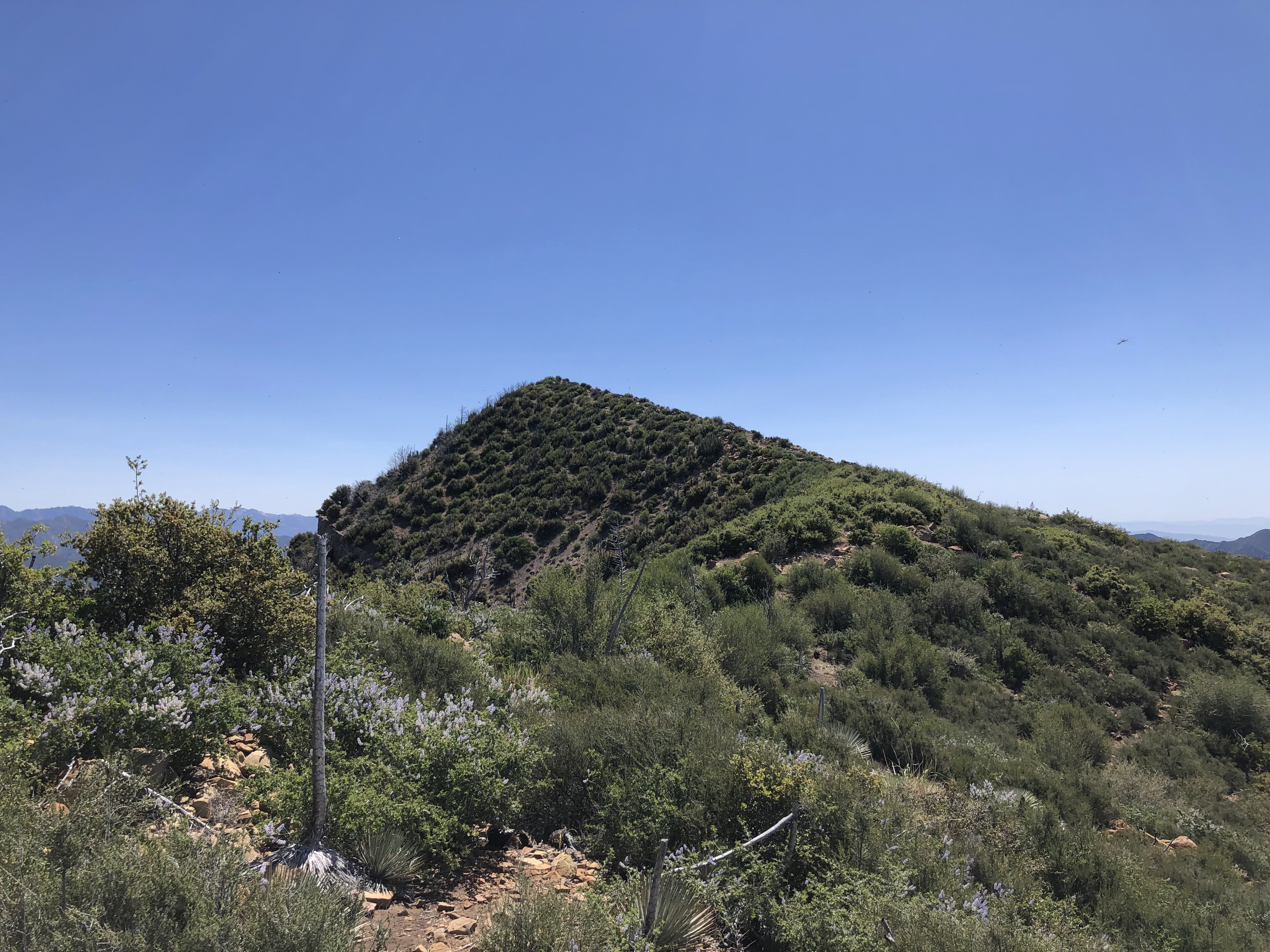
Old Man Mountain

View west, Jameson Lake bottom left

I reached a high point that gifted me a lovely view of Old Man Mountain's southern summit. A fairly mean wind had picked up, whipping against my face and shirt and probably carrying away a few ticks in the process. To my relief, the wind wasn't warm, which meant that it couldn't be more than 85℉ or so. Granted, it wasn't even 8am yet, and I knew that this wind would only get warmer as the day grew long. I sat down, drank more water, wolfed down some calories, and then continued on my way.

I lost some elevation and then immediately gained it back. The sun got higher, the wind died down, the rocks remained silent and the ticks finally went into hiding. Sort of. I guess most of them don't like the heat too much. I was only picking up a couple of 'em every fifteen minutes now, a significant improvement from earlier that morning. 

Monte Arido

I rounded the western flank of Old Man Mountain and got my first good view of Monte Arido. Dang, that thing still looked a long ways off. But I didn't care. Putting one foot in front of the other would get me there sooner of later. I kept going, stopping only to hydrate.

Eventually, the road finished wrapping around the western side of Old Man Mountain and headed north. At this point I was gifted with an insane view of Old Man Canyon. It stretched for miles before me, reaching down and away into Matilija Canyon and beyond. I immediately thought of David Stillman's descent into that canyon all those years ago, well before all the brush burned away in the Thomas Fire. Since the fire, the brush has already made quite the comeback. I could only imagine how insane it looked before it burned. Standing there, looking down into that canyon, all I could think to say was "that man is insane." 

Old Man Canyon

The road became exceptionally steep after this viewpoint. I moved up the thing little by little, digging my trekking poles in the dirt to propel me upward. Monte Arido never seemed to get any closer. I could feel the salt accumulating on my face, the sweat running down my back, the popped blister on my achilles and the lactic acid accumulating in my calfs. I stopped looking at Monte Arido, no longer concerned with progress. Staring at it wouldn't do me any good anyways. I told myself that I'd get there when I'd get there. Head down, arms pumping, legs zoomin'. I found a groove and took it, waltzing up the trail in the heat. 

Gettin' closer...

There were some huge bear tracks in the road. Old ones, made during a time when the road was nice and muddy. Why a bear would wander all the way up to this exposed and windy land is beyond me. Perhaps there was a water source nearby that I didn't know about. Maybe the deer are extra tasty up in these hills. I don't know. I followed the tracks for a ways, following in the footsteps of the bear until they left the road and entered the brush. 

The road headed west, I saw a rise and scurried up to the top, believing it to be the summit. It wasn't. Doh! I'd been fooled by a false summit yet again. Seems to be a pattern with me. Gotta stop being so hasty. It costs too much energy. 

I could see the summit from my vantage point, no more than 500ft in front of me. I scurried on over there, taking a breather on this little rock right next to the register. Monte Arido sure lived up to its name: its summit is nothing but a big, wide, flat, dry, arid expanse with decent views of the surrounding country. I had to walk a little bit in each cardinal direction to get a good look my surroundings. Madulce Peak, Big Pine Mountain, and two of the mountains I had climbed the week prior (McKinley and San Rafael) lay to the west, looking rugged and tired. The Santa Ynez Mountains stretched off into the west, running in a bumpy line until they disappeared into infinity. To the north was the dry country, nothing but a desiccated landscape where only the hardiest of species survive. Southward lay the pacific and four of the Channel Islands: Anacapa, Santa Cruz, Santa Rosa and San Miguel.


Northwest(ish)

Southwest(ish)

Northeast

To the east was, in my opinion, the best view of all. I could see almost every major summit of the Sespe and Matilija Wildernesses, from Cara Blanca all the way to Cobblestone. Rugged, rugged country. I could see it all, could see Reyes Peak and Thorn Point, Ortega Hill and the Nordhoff Lookout Tower, Hines Peak and the Topatopa bluffs, Santa Paula Peak and the Santa Monica Mountains. I stood there for a bit taking lots of pictures, my eyes overwhelmed with sensory information. This is the country that I know best, so it was great to see it from a new vantage point. 

East

There were three booklets in a plastic register, two old and one new. The new one was placed in 2018; the last entry was from March 23rd of 2025 from a guy who did an out-n-back from Hwy 33. Seems like a lot of people go this way, perhaps to avoid the crazy elevation gain from the bottom of Matilija Canyon. I left my marks, screwed on the lid, and then made my way off the summit. Old Man Mountain lay far below, its twin summits shining bright in the late morning sun. 

Old Man Mountain, Old Man Canyon

I raced down the road in a flash, the steep grade no longer a hassle to my legs. I made it to the northern base of Old Man mountain in no time, stopping just once along the way to guzzle more water. I left the road for the use trail, following it through dirt, brush and boulders. 


No more wind, not even a breeze. Just stifling, dry, HOT air everywhere. The sun was close to reaching its zenith, the heat of the day now ramping up exponentially. I was feelin' it now, sweating buckets and busting through brush. The use trail avoided the worst of it, but at times it vanished and I was forced to shimmy my way through head-high chaparral. I gained the summit ridge and banged out the last few hundred feet to the summit without much issue. 

Ahh, Old Man Mountain. What a fantastic peak. Though the weather wasn't as clear as it was the last time I was up there, I could still see most of everything. I still hold firm to the notion that Old Man Mountain has the best views out of any peak in the Los Padres. It's definitely worth the trek to the top, no question. I sat down for a minute, downing electrolytes and taking in the view. I located the register and signed my name for the second time. The previous entry was from the same guy who had climbed Monte Arido on March 23rd 2025. 


I didn't spend too long on the summit, what with the constantly rising temperature and the millions of bugs trying to suck my eyes dry. Not wanting to back track, I decided to summit Old Man's southern peak. I remembered it being a fun little climb, and as a bonus I'd be saving myself a whole lot of road walking. So I gathered my things, took one last sweep of the summit views, and then set off.

The climb to the southern summit wasn't nearly as hard as I thought it would be. Not too brushy, not too many ticks, fairly solid ground. Good stuff, good stuff. I topped out on the rocky summit and took another break, feeling the heat emanating beneath me. 


Wow

The old can was still there, but I was unable to find the tiny register. Oh well. Didn't matter. That thing was full when Liam and I first climbed this peak back in 2022. I doubt I would've been able to leave my signature had I been able to find it. 

Electrolytes, calories, plain ol' water, granola bars. I fueled up, taking in the magnificent views of the Matilija wilderness. White Ledge Peak, King's Crest, and Divide Peak were well in view, looking gnarly and green and rocky and hot. I stuck out my tongue and tasted the air. Tasted like 90℉ to me. That meant it was time to go. 

I left the summit, sidehilling for a ways down the steep southern face to a flat spot. From there it was a hop skip and a jump through shin-high grass and the occasional yucca back to the road. I put my legs in cruise control and set off down the road, the miles slowly passing underfoot as the day only grew hotter. 

At one point I met a snake in the middle of the road, a long thin line sitting still as a statue. I grabbed its tail and tried nabbing its head, but it kept trying to bite me and I got too scared. I let it be, apologizing for ruining its midday sunbath. It slithered away into the bushes, never to return.


More miles, more heat, more water, more sun. I pressed against the northern side of this one large boulder, taking a little breather in the only good shade around. I sat down, my torso in the shade, my legs in the sun. I checked my water supply; still good. It was quiet there, no birds or wind or anything. Just bugs. But even they seemed tired from the heat, buzzing lazily around my face without much urgency. 

Back on the "road"

I got up, dusted off my pants, and coasted the rest of the way back to Murietta Divide. No ticks this time. I suppose they'd returned to their little tick homes and turned on their little tick air conditioners. The hard part of the day was far behind me. Now all that remained was the long, uneventful downhill grind to Matilija Canyon. 


I never stopped. Not once. Just coasted the whole rest of the way down. I made it back to the trailhead, finishing the whole thing in just under nine hours with water to spare. There was one other car in the lot that wasn't there that morning. The occupants must've ventured off to the Matilija Falls. I never saw 'em. Had the whole day to myself; never saw a single soul the entire time I was out there. Couldn't imagine why, hahaha. 

I stretched, drove home, took a shower, got a haircut. It had been yet another excellent day on some quality peaks. The only downside was that I decided to wear brand-new shoes fresh out of the box. Twenty-four miles and 6,000ft of elevation gain definitely broke them in, but not without some casualties. I got this nasty blister on my left achilles that to this day is still not fully healed. Oh well. Yah live and yah learn...


Friday, May 30, 2025

Cachuma Mountain, McKinley Mountain and San Rafael Mountain

05/15/25


I've been spending too much time in the Sespe Wilderness as of late. Needed to change things up, see some different sights, visit a part of the forest I ain't ever been. Particularly one with plenty of trees, views, and pointy summits. 

The giant swath of the Santa Barbara backcountry came to mind. I've only visited that country just once, and that was a very long time ago. Eleven years to be precise. Gnarly trip. Walked from Nira all the way up the Sisquoc to Madulce Station, then attempted to make it to Dutch Oven Camp but got turned around. Backtracked to Madulce Station, went from there to Bluff Guard Station, down to Pens Camp, through the Indian Narrows and "The Perfect Ten," and then out to Mono and P-Bar Flats. Most people will have absolutely no idea what a trip like that even means, but for those who know the country or have even been to some of the spots I've mentioned know what I'm talking about when I say that that trip was rough. That trip was my first and last good taste of the San Rafael and Dick Smith Wildernesses. I loved it, but it scared me a little. Well, it ain't scarin' me no more. There's some peaks out there that I needed to check out, peaks that could help me observe this country of which I know so little about. 

Peaks are a great way to get to know an area. They give you expansive views of the surrounding country, helping you understand the lay of the land. When I was truckin' it on the Manzana and Sisquoc trails all those years ago, I recall looking to the south and seeing these high, snow dusted peaks. I've always wondered what was up there ever since, what kind of views they had, what could be seen from the summits. Recently, I discovered three prominent peaks in them mountains: Cachuma Mtn, McKinley Mtn, and San Rafael Mtn. These were my desired summits. And as a bonus, almost all of them could be accessed via bike. And you know I just love a good bike ride. So I loaded up the ol' bike and drove off towards Santa Barbara. 


I took Hwy 154 to San Marcos Pass, noticing tall flames and thick smoke hovering near Painted Cave. It looked like a controlled burn, at least that's what I hoped it was. I drove on, coasting down the pass until exiting on Armour Ranch Rd. From there I turned right and took Happy Canyon Rd the rest of the way to the trailhead. I don't know what was so happy about that canyon, but it was a very pleasant drive nonetheless. Lots of lazy oak trees, tall grass that was just beginning to turn golden yellow, sleepy cows, ancient barbed wire fences, and ranches and houses that looked like they came right out of a Steinbeck novel. There were two cyclists with very muscular legs suffering their way up the steep grade to who knows where. I looked at them and thought, "gee, that doesn't look like any fun at all." Funny thing was that I was about to do the same thing on a dirt road in just a few moments. 

I made it to the trailhead and pulled off the side of the road. There was a lot of construction going on everywhere, with several trailers and heavy equipment taking up the entirety of the dirt parking lot. A construction guy politely informed me that I had to move my car, so I drove a little ways up forest route 8N08.1 to the closed gate. There was one other car parked there. I got out the bike, drank some water, and then set off on my journey into the mountains a little before 11am.

The road was immediately steep and it remained steep for a long time. Kinda reminded me of the first part of Sulphur Mountain Rd out of Casitas Springs. Very steep, but also beautifully maintained. No ruts, no massive rocks, no damage of any kind. Luckily, all those months of biking to work payed off, and I was able to zoom through the beginning steeps of the road with relative ease. Squirrels scurried up and down the various trees that lined the road, the local birds filling the air with their late morning song. There was a snake sunning itself in the middle of the road. I stopped and tried to catch it, but it was too quick. I got back on the bike and continued along, sweating buckets despite the relatively cool weather. 

I rounded a corner and was gifted views of the Hurricane Deck. I've only seen the Deck once, so it was a little weird seeing it again after all these years. Looked exactly how I remembered it, just a little farther away. I stopped pedaling, got off the bike, and took the time to enjoy the view. 

Hurricane Deck

The grade lessened a little ways after this viewpoint, giving my quads and calfs a chance to breath. I could see my first objective, Cachuma Mountain, looming ahead of me. It looked like a great little summit. I rounded another corner, now gifted with views to the east. Mission Ridge, San Rafael and McKinley Mountains were in plain view, big and green and distant. I pedaled to the eastern base of Cachuma Mountain, stashed my bike, and then began the short climb to the summit. 

Cachuma Mountain


On my way up, I noticed a small speck making its way down the road. This must be the owner of the vehicle I saw parked by the gate. They were walking at a slow pace, carrying what looked like a 50L backpack. A small part of my mind was screaming "I hope that sonuvagun doesn't nab my bike" but I silenced it, knowing that such an event would be highly unlikely. People are generally very kind in the woods. Why negative thoughts come to mind must be a result of spending too much time in civilization. The figure walked along, passed my bike, and continued down the road without breaking stride. I never saw them again, nor did I see anyone else for the rest of the day. 

The climb to the top of Cachuma Mountain was short but very steep. It took me a minute to swap my biking muscles for my hiking muscles. I stumbled up the steep slope, following the occasional cairn. I topped out on the summit in good time, enjoying the nice 360° views of the surrounding country.

West

East

South

To the west I could see Ranger Peak, Figueroa Mountain, Zaca Peak, and the large burn scar of the 2024 Lake Fire that devastated much of that area. Down below, looking like a toy set, I could see the construction sight. Heavy equipment rolled about, the sound of diesel engines and shouting voices reaching my ears. To the east were lovely views of the two additional peaks I had yet to climb. I was more concerned with the thin line of the road snaking its way towards those peaks. Looked long, steep, and fully exposed to the sun. 

To the north were improved views of the Hurricane Deck and the Sierra Madre Mountains, and to the south I could see the wide expanse of the Santa Ynez Range stretching from east to west. San Marcos Pass looked tiny from the summit, the sharp glint of the occasional car reaching my eyes. Lake Cachuma was a lovely blue jewel, filled close to capacity thanks to last year's rains. I spent most of my time on the summit looking at this southern view, noticing that there was no longer any smoke rising from the Painted Cave area. Must have been a controlled burn after all.

I located the register, made my marks, and found out I was the first person to summit the peak this year. The booklet was placed on Feburary 13th of 2016; the most recent entry was from November 30th of 2024. Seems like most people skip this peak in favor of McKinley and the other high peaks. I don't see why anyone would do such a thing; Cachuma was a great little climb with marvelous views. 

I spent a good chunk of time on the summit, drank some water, shoveled down some food. The bugs were out in full force, trying to suck the water out of my eyes. I paid them no mind. I put the register away, waved goodbye to the summit, and then made my way back down to my bike. Once there, I saddled up and kept on truckin' along the road, coasting the downhills and powering through the inclines. 

Hell's Half Acre

I eventually made it to a spot known as Hell's Half Acre. Passed right next to it on the side of the road. Not too sure why it's got such a spooky name or if it's even a true half acre in size. From what I could see, the place looked like a cool collection of rocky boulders surrounded by mean, pokey brush. Worth exploring? Maybe. I had bigger fish to fry, so I gave it a pass.

It wasn't long after passing Hell's Half Acre where the road deteriorated quite significantly. Ruts, divots, big ol' rocks everywhere. It was also at this point where my quads decided to give up. I'd been biking steady all morning and the steep grade wasn't agreeing with my legs anymore. My experience biking to work on a paved road helped at first, but this was a whole other animal. I walked my bike a lot from that point on, pushing it up the steep grade, slipping every so often, the sweat pouring through my eyebrows and into my eyes. I thought about ditching the bike and just walking the rest of the way—that would be much easier. But I knew I'd want it for that sweet, sweet downhill, so I kept at it, pushing the contraption up the road one step at a time.


I took a break in some glorious shade, sitting in the dirt amongst the oaks. Much of the ground was littered with dry acorns and their caps, crunching loudly every time I shifted my weight. It couldn't have been more then 80℉, but I was absolutely soaked in sweat. Good thing I brought plenty of water. Ain't gonna make that mistake again, I tell you what!

Back on the bike, back to the grade, the acorn caps popping under my tires, the miles passing slowly one after the other. I'd ride a little, walk a little, drink more water, sweat it out, repeat, repeat, repeat. I'd go up, then down a little, then back up, then down a little, and then up a steep incline so crazy that it must've been specifically designed to make my calfs cry and my quads whimper. Eventually, I passed McKinley Springs, a nice little campsite in the shade of several old oak trees. No time to stop, though. I had a mountain to climb. I pushed onward, not stopping until I topped out on McKinley saddle.

Santa Cruz Peak


I could see Santa Cruz Peak from McKinley Saddle, distant and brushy and foreboding. I've heard of a local challenge known as "The Big 3," which involves climbing McKinley, Santa Cruz, and San Rafael all together. It's a 30+ mile trek with wayyy too much elevation gain for my liking. Most people do it over a day or two, others bike it, and some crazy freaks walk it on foot in a single day. Looking at it from the saddle, I briefly thought about venturing down the abandoned and brushy road to the summit, but I knew I didn't have enough time. I basically started the day at 11am for cryin' out loud. If I had started earlier, then maybe, just maybe Santa Cruz would be in the cards. But not today. I stashed my bike in the shade, adjusted my pack, and then set off on the short trail to the summit of McKinley. 

On the way to McKinley

It was a lot more gentle of a climb to the summit of McKinley than it was to the summit of Cachuma. The trail was steep at first, but then it leveled out; nothing but a nice, easy walk to the top. A breeze had kicked up, sparing me from the thirsty bugs. I made it up with minimal effort, sitting on the summit rocks and soaking in the impressive views.


Someone had mentioned in the Cachuma register that the views on McKinley were worse than those on Cachuma. I don't know what they were on about, because the views from McKinley were far superior. More grand, more wide, more expansive, more "airy." Though the climb to the summit wasn't as interesting, the views from the summit more than made up for it. It was basically the same view as that on Cachuma, the same landmarks and everything, but with a little extra zing. McKinley was essentially "Cachuma Premium." I spent a good 20 minutes on the summit, the breeze keeping the bugs away, the clouds twirling in the sky. Very peaceful up there; the sounds of civilization never met my ears. For the first time that day, I felt like I was finally out there. And it felt damn good. 


There was a shiny new register on the summit, placed on April 27th of 2024. The last entry was from April 8th of 2025. A lot of the entries were from those attempting "The Big 3." Crazy folks. I won't be doing that any time soon, believe that!

I gathered my things, ate an energy bar, and then left the summit. Two down, one to go. I spent much of the descent looking at San Rafael Mountain to the east. It was close, but I knew it was still a two mile trail walk to the top. Suits me. A break from biking and a shift to hiking was music to my ears. 


Not much left of the ol' sign...

I started on the Mission Pine trail, a welcome relief from the endless road miles I'd been traveling for most of the day. The trail was absolutely exquisite, slowly gaining elevation through a dense forest of hardy chaparral. Buckthorn, scrub oak, chamise, manzanita and more—it was all there and it smelled heavenly. The clouds in the sky had grown more puffy, casting large shadows on the surrounding country. It's crazy how something as simple as a cloud can make an area 10x more scenic. I stopped often, snapping one photo after another, observing the clouds and their shadows and the chaparral and the purple patches of lupine shining brilliantly in the afternoon sun. 

San Rafael Mountain

The trail passed right next to the summit of San Rafael Mountain, making it the easiest climb of the day. I was more curious with the rest of the ridge though, so I ventured a little farther down the trail through the pines to this little outcrop of sandstone boulders that caught my eye. I scaled the boulders, took a seat, and enjoyed the best views I had seen all day. Before me lay the rest of Mission Ridge, isolated, rugged, full of scraggly pines and sandstone formations. It looked a lot like the area between Reyes Peak and Thorn Point, just a lot more wild. Way off in the distance, I could see Big Pine Mountain, Samon Peak, and Monte Arido and Old Man Mountain. Even farther away sat the Cuyama Badlands, Cerro Noroeste, and Mt. Pinos—the highest point in Ventura County. 


I nibbled on a granola bar, taking in the scene one chunk at a time. Ah yes, now this is what I was looking for, this is what it was all about. I absorbed the lay of the land, pointing with my finger the various landmarks I recognized and those of which I was unfamiliar. I felt so small up there on those boulders, so isolated, so free. It was a strange sensation, one that I haven't experienced in a long, long time. 

I only spent about 10 minutes on those boulders, but it felt much longer. Once I'd had my fill, I packed up my things, waved goodbye to the vast expanse of wilderness that lay before me, and turned back towards San Rafael Mountain. 


I took my time, traveling silently amongst the pines. I had no idea I would be walking in such an environment that morning, so I savored every moment of it. I'm a sucker for Jeffrey Pines; I love the way they look, I love their vanilla smell. The way the wind moves through their needles and the crunchiness of their pinecones and the roughness of their bark—I love it all. I walked slow, taking pictures of these quiet, wonderful trees. But soon they disappeared and I was back to the regular scene of rugged chaparral. 


View east


I reached the summit, took a seat. There were three booklets in the register. The one I signed was placed on November 25th of 2023. The most recent entry was from May 10th, just five days prior. I didn't spend too much time on the summit, taking only enough time to snap a few pictures and do a quick sweep of the area. I still had a long way to go, worrying that it could be even longer if one of my tires deflated. Man, that would totally suck. I trotted down the trail, praying that I didn't run over thorn on the way up. 


Back at McKinley saddle, I stopped for a moment to sign the trail register. Lots of hikers and bikers and backpackers had made their entries, all of them loathing the dreaded miscreant who rides their dirt bike on the Mission Pine Trail. Someone warned that they'd personally boobytrapped the trail specifically for bikers. That gave me a little chuckle. I signed my name, thanking those who go through the effort of maintaining the trail. Without their efforts, cool backcountry trails like this one would soon disappear. 

I returned to my bike, relieved to find both of the tires full. Hallelujah. Now all I had to do was to take it slow and try not to crash on the way down. I said my goodbyes to the saddle, kicked the bike into gear, and then set off down the road.

Along the way, I made a quick stop at McKinley Spring. There were two sites, the western one being the nicer of the two. Both of the tubs were full of clear, cold water. I poured some on my head, washing away the lines of salt that had accumulated there throughout the day. 


From then on it was an adrenaline-fueled, white-knuckled descent down the crazy road. It was a good thing I'd brought my helmet because, despite my best efforts, I still managed to crash a few times. I'd slow down to a crawl, hands tight on the breaks, and then I'd hit a rock or fall into a small divot and have to ditch the bike. If I didn't, I'd fly right over the handle bars. I've already done that plenty of times in middle school, and I didn't feel like doing it again on this glorious day in the mountains. I got off the bike and walked down some of the steeper sections, not wanting to risk the chance of another crash. 


Walking, biking, walking biking. I walked much of the way around Hell's Half Acre, taking the time to really look at all the formations and whatnot. After that, I hopped on the bike and was able to ride it most of the way back to the car. The last little bit from Cachuma Mountain to the gate was especially fun, reminding me of Shelf Road in some spots. Man, bringing the bike was a fantastic idea. Zooming down that road without pedaling, the wind ripping across my face, everything passing by in a blur—it was plain awesome. 

When I returned to my car the other vehicle was gone, the sounds of construction no more. The whole day had taken 6½ hours, but it felt much longer. It was a good day in the woods. Saw some stuff I ain't ever seen, saw some old spots from a new vantage point, got to enjoy a little solitude. All good stuff.