Saturday, August 31, 2024

Unfinished Business on Mt. Irvine


I had climbed Mt. Irvine ten years ago, reaching a point 200ft from the top. We had to turn around due to time constraints, something that was quite frustrating given that we were so close to reaching the summit. We nearly made it. Oh so tantalizingly close! But lo, we had to turn around, climbing down the mountain in defeat. And so, for ten years, that failure has been stewing in the back of my mind. I had to put an end to it. Had to seal the deal. Had to climb the whole thing. Had to reach the summit. Otherwise, it would just keep there stewing and brewing in my mind until I went crazy. 

I left on Tuesday, the 27th, bound for the Meysan Lake Trailhead. It's located about half a mile from the famous Mt. Whitney Trail. I drove all the way to the Portal for a quick bathroom stop, arriving just before 2pm. The place was packed. Folks were walking around everywhere, some wearing big packs, some wearing no packs. The Whitney Store was stuffed with people and every spot in the parking lot was occupied. The same can not be said for the Meysan Lake Trail. For whatever reason, this trail is wayyy less popular, despite it being only half a mile from one of the most highly trafficked trails in the country. I parked on the side of the road, grabbed my overnight stuff, and set off for the trail.

I had to walk through the Whitney Campground for a bit to get to the actual trail. This place was full as well. Every spot was occupied with camper vans, flatbed trucks, tents of all shapes and colors. I found the trailhead and immediately began gaining elevation, walking next to what I believe are summer chalet rentals. Soon, I rounded a corner, entered the main canyon, and left all that hullabaloo behind. 


The trail to Meysan Lake is a steep little thing. There's hardly any relief. It's just up, up, up. I went up switchbacks to the border of the John Muir Wilderness. And after that, more switchbacks. If there were no switchbacks, it was just a steady uphill. Various pines lined the trail, offering much needed shade. But soon I was trekking through the higher altitudes and the shade mostly disappeared. 

The canyon was surrounded by high granite cliffs, Lone Pine Peak to the south, Candlelight Peak to the north. A rushing stream could be heard at the base of the canyon, the only other sound being the occasional screech of some crazy bird or the breeze rustling through pine needles. I met just four people on my way up, all of them day hikers, all of them coming back down after a long day in the sun. I was the only one hikin' up. I trudged along, my calves burning from the steep grade and excess weight from my overnight gear. 

Looking back towards Lone Pine

Lone Pine Peak

Most of the trail was in decent shape, but there were a few sections that were washed out. In these sections little rock cairns marked the way, likely placed there by good samaritans. I stopped a few times, admiring the view and resting my burning calves. I hadn't done an overnighter in quite some time, and my legs were not prepared for the extra weight.

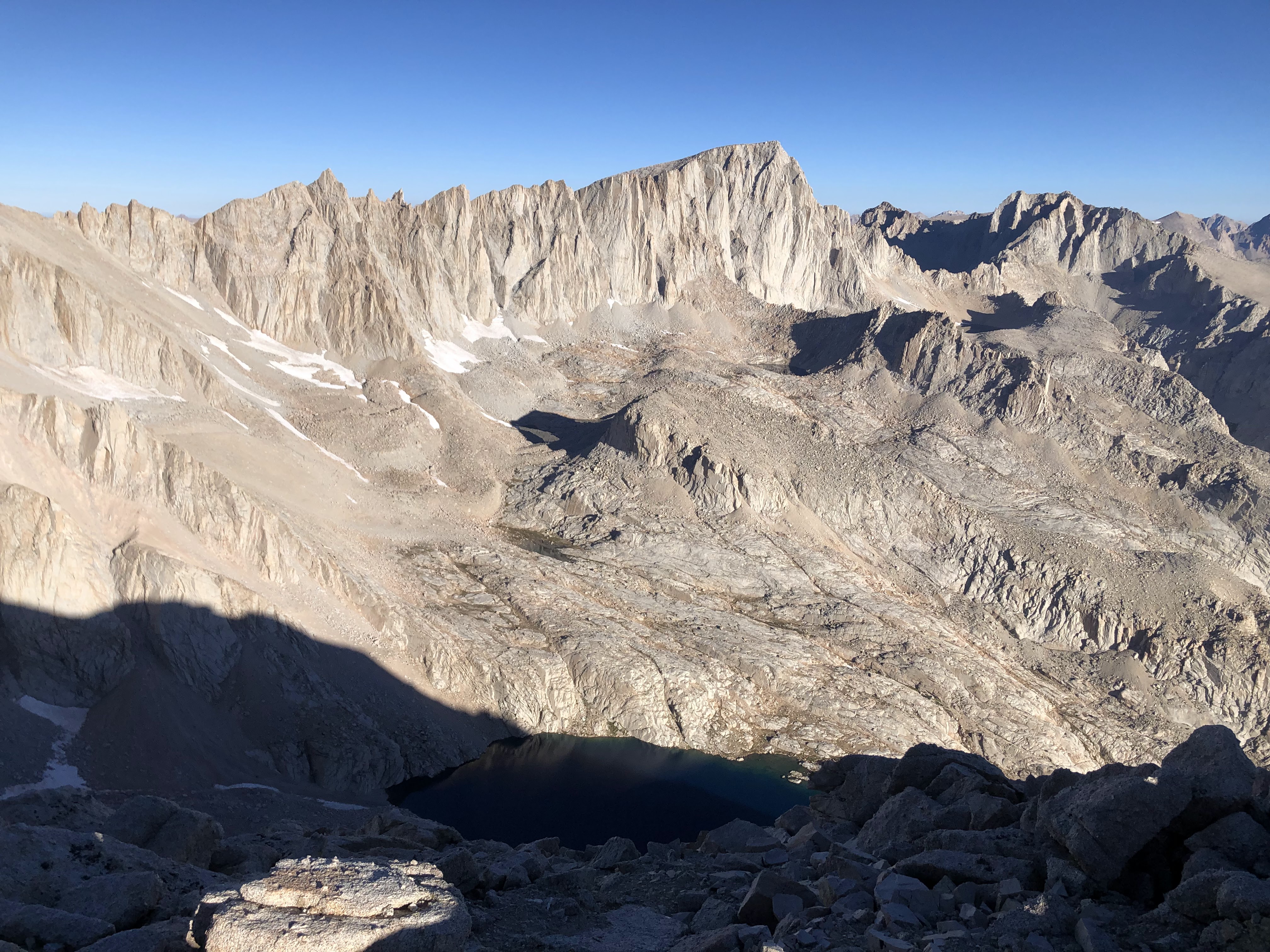
I eventually made it to a fork where the trail splits to Grass Lake or Meysan Lake. I made a right and continued to Meysan Lake. Mt. Irvine could be seen to the west, looming tall and foreboding. It looked as intimidating and magnificent as I remembered it ten years ago. High, sheer granite cliffs mark its east face, rising to a jagged point in the sky. I passed by Camp Lake, a small, trout filled body of water surrounded by wild grasses and bristlecone pines. From there it was a steep climb up a small hill to the overlook of Meysan Lake. Here the trail pretty much disappeared, but I found a well cairned route that took me to the overlook without much difficulty. 

As I was hiking up the hill, staring at Irvine, a thought swam through my mind telling me that I shouldn't climb it in the morning. Was it fear? Doubt? Laziness? A combination of all three? Most likely. But I put those thoughts away and continued the short but steep climb up the hill, wondering if Meysan Lake still looked as beautiful as it did ten years ago.

Mt. Irvine

Meysan Lake

When I made it to the overlook all fear, doubt, and laziness left my mind as I gazed upon the magnificent lake that lay before me. It rests in a bowl, surrounded by high peaks and blue skies. A glorious blue jewel of varying hues. Dark, cold, deep blue in the shade, turquoise and teal in the sunlight. Not a sound met my ears as I gazed in wonder. No breeze, no birds, no nothing. I felt an extreme sensation of tranquility and calm, and I forgot all my worries for a while.  It looked exactly as I remembered it, and for a moment I was transported back in time to when I first saw it. It was a strange feeling. 

I descended to the lake, noticing that there was one other group camped there. They were Boy Scouts, just two of them, camped on the cliffs above the lake's northern shore. They were taking turns with the fishin' rod. They weren't having much luck. Asked them if they'd be climbin' any mountains in the morning. They said no, stating that they were plenty satisfied moseying around the lake looking for fish. I found a spot on the eastern shore, protected from the wind, with an excellent view of Mt. Irvine and the surrounding peaks to the west and south. I had hiked a little over six miles with about 3,800ft of elevation gain. Time for a long rest.


Mt. Irvine's east face from Meysan Lake

Mt. LeConte from Meysan Lake

I hung around the lake for a bit, filtering water and psyching myself up for the climb tomorrow. I was planning on taking the east slopes, hitting Mt. Leconte and Mt. Mallory first and then traversing to Irvine, but the way was obstructed with snow. I had not brought crampons or an ice axe, so that plan was kaput. My other plan was to go up the same way I went ten years ago, but why do something I've already done before? So that left me with the east chute, something that was a mystery to me. I'd read that it was steep class 2 with a short class 3 section, but I've learned that those ratings are entirely relative. I'd have to scout it out myself to see what it was all about.

I spent many a long minute staring at that chute from the lake, planning my route, wondering what it looked like up there. The more I thought about it, the more I didn't want to do it. The lake was so peaceful and calm. I could spend a whole day just sittin' there on the shore and relaxing. Why bust my butt up a mountain? I knew it would suck. I knew it would be hard. Why do it? I didn't even have to do it...the lake would be so much better...


I read for a while, watched the sun set, and then went to bed, dressing in all of my layers as the temperatures plunged to the upper 30's. It was one of the worst sleeps of my life, if you could even call it sleep. No matter how comfy I got, I just couldn't fall asleep. My heart was thumping in my skull, the high altitude starting to get to me. I'd toss and turn, never finding any relief. At around 3:30am, I erased my alarm, deciding there and then that I wouldn't climb Irvine later on in the morning. I'd be wayyy too tired. I continued to toss and turn, occasionally opening my eyes to see the moonlight bleached granite cliffs and dazzling stars. The night drew long, the stars moved along, and then the sun made its presence. I was still awake. It was just before 6:00am. I let out a groan. With sheer willpower, I lurched out of my sleeping bag, said something like "screw it," and gathered my gear for the climb up Irvine. I was out of my tent and topping off my water by 6:10am. The climb was on.


I wasn't thinkin' much. I just new I had to climb this mountain. I'd come all this way, I'd spent the night, by golly I was gonna climb it! I had unfinished business with this mountain. It was time to settle it once and for all. 

I made good time across the southern edge of Meysan Lake. I took the path of least resistance to the boulder field at the base of the east chute. I crossed a small snow field. And then I was climbing. And climbing. And climbing. Man, there ain't nothin' like climbing up steep class 2 terrain right after getting up out of bed from a sleepless night on an empty stomach and no caffeine. Yup, I didn't even make breakfast. I just went for it. 

The boulders were a bit tedious to get through, and beyond that it was a steep climb up loose rocks and scree. I had to double check every step I took, because it would most likely give way under my weight. I made it to a narrow section of the chute, observing the class 3 obstacle. It didn't look bad at all. Solid holds, maybe fifteen feet of climbing at the most. I scrambled up it without issue and pushed on, stopping every now and again to enjoy the cool morning air and the rising sun. 

Goin' up the chute

Rosco Peak in the distance

There was some running water in the chute, dripping off the remnants of hard packed, frozen snow. The granite glowed a brilliant gold in the early morning sun, bright, shiny, spectacular. I was actually enjoying myself for a moment, just scrambling up that chute. If it stayed like this for a while, it wouldn't be too bad. 

The chute widened out to a large bowl that separates Mt. Mallory and Mt. Irvine. I hung right, heading towards Irvine. I climbed up the remaining steep portions of the widening chute to a point where I could make out the summit. It stood a ways off. A huge, steep, boring slog up boulders and scree would be required to reach it.

Mt Irvine summit, center left

I almost gave up in the bowl. It was long and tedious walking, my feet sinking in the fine, sandy granite. I was pretty tired. Pretty beat.  And then I remembered that I hadn't eaten anything and I pulled out a Cliff bar and wolfed it down like Popeye with spinach. A wave of energy rushed through me, and I chugged out the remaining chunk of the slog to the summit in no time. 

Mt. Irvine Summit

I saw where we had to turn around ten years ago. My oh man were we close. Just another five minutes of walking and we would've made it. But no matter. A lot of the view was exactly the same as I remembered: Mt. Mallory, Mt. LeConte, and Mt. Langley to the south, Lone Pine Peak and the Owen's Valley to the east, and Mt. Whitney and company to the north. The only thing new was the view to the west. I could see Mt. McAdie up close, Arc Pass beneath it, Consultation Lake a dark blue orb in a sea of granite. Distant peaks of which I am unfamiliar dotted the western horizon, far, remote, mysterious. I sat up there for a good ten minutes, soakin' up the view, feelin' satisfied for finally settling the business of summiting. Was it worth it? Hell yeah it was worth it. Mt. Irvine is a pretty dang cool mountain with pretty dang good views. 

View southeast(ish)

Mt. Whitney and Co. 

Mt. McAdie

View northeast

The register was placed in 2007. The last person up there summited on the 20th. The pen was almost out of ink. Pro tip: if you ever plan on hiking up a mountain, bring a writing utensil. I hung around for a few more moments, ate another Cliff Bar, and then began the fun descent off the mountain. I wasn't entirely at ease. Sure I was stoked that I'd made it to the top after all these years. But the climb was only halfway through. The descent is just as important. I'd feel relaxed once I made it back to the lake. Until then, I was locked in. 

View east


What caused me so much pain and anguish on the way up now provided me with sweet, sweet relief. I flew down the scree and sandy granite, digging my heels in the ground as I zoomed down the mountain. I made it to the top of the chute in what seemed like no time and then it got serious. As it turned out, it was actually a lot easier climbing up the chute than climbing down it. Everything was steep and super loose, and I fell on my butt a few times, scraping my hands and fingers on the sharp granite. Three points of contact at all times became the name of the game. I had to test every boulder and rock. Very tedious. Man, even the big ones moved. I'd see a boulder, one weighing damn near 300lbs, lodged in the earth, sitting still and stoic, and I'd step on it and then it would roll out from under me. I couldn't trust nothing. Consequently, it took a good long time to get down that chute. A full body workout ensued. Scooting, sliding, squatting, slipping, hopping, gliding. It was a grand ol' time. 

Looking back down the east chute

The class 3 obstacle, viewed from above

I scrambled up a ledge in the chute to get a view of the lake. I could also see the class 3 problem beneath me. What was easy on the way up was sketchy as ever on the way down. The rocks above the problem were loose as can be, and the idea of slipping and then falling 15ft didn't sound too good to me. So I took my time, scooted on down that jazz, and then I was home free. I hopped down the rest of that chute and was back at the lake in two shakes of a lamb's tail. The whole climb up and down took about three hours, but it felt much longer. I rested in the shade of a large boulder and took a long break, watching the sunlight glimmer on the lake's surface. 


It was a little after 9:00am. I could see the Boy Scouts on the other side of the lake, fishing. I had some time to kill so I walked back to camp, took down the tent, and then read for a few hours. I'd take a break from reading every now and then and walk down to the water's edge, watching the fish catch flies on the surface. I counted 12 good sized trout. Healthy, shiny, strong. As the day grew long the water turned from a navy blue to a blueish green. Eventually it would be turquoise, but I didn't stay long enough to see this transition. I had a bit of a walk ahead of me, and a long, long drive back home. I left the lake a little after 11:30am, saying my goodbyes and thanking the mountain for a safe and successful journey. 


The trail passed underneath my feet in a blur. I just trucked on out of there, gliding down the switchbacks, not paying attention to much. Only met two people on the way down. They were heading up to Meysan Lake. Asked how the water looked. I told them about the fish. One of them said, "Oh don't tell me that, I didn't bring my pole!" We went our separate ways. 

I made it back to the trailhead, my knees were dead from the downhill. But I didn't care. I'd settled the business with Mt. Irvine and I could now rest easy. It was a pretty good outing. As a matter of fact, 'twas my first time doing a solo overnighter. Kinda spooky. Kinda uneasy. Kinda liked it. I foresee more of these types of adventures in the future. But for now—rest. 

Friday, August 23, 2024

Mt. Muir, Mt. Whitney, Keeler Needle, Crooks Peak


My boss was kind enough to let me leave work early. I drove from work all the way to the Whitney Portal, nabbing a spot right next to the trailhead. That was pure luck. On my way up I noticed several cars parked along the side of the road, which was a good sign that the lot was full. And it was. Finding that spot right next to the trailhead was highly fortunate. My legs would be grateful for it later.  

The moon was nearly full. On my way up I could see the mountains to my left, the pale light of the moon reflecting off the granite. There were people milling around in the lot, some starting the trek up the trail, others setting up their beds in their cars and such. One car had its headlights on and they stayed on, all through the night. I set up my pad and blanket and tried to get some shut eye before the big day. I'd be going from sea level to the highest point in the contiguous United States with absolutely zero altitude training. Anything I got from Langley, a peak I climbed over a month ago, had long disappeared. My best bet was to acclimatize in my sleep.

It was a rough sleep. People were coming and going at all hours of the night. At one point a truck pulled up right next to me. A bunch of dudes spilled out of it, shining their headlamps in every direction as they gathered their gear. For some reason they kept saying "oui monsieur" to each other. They were not French. One of them would say something like, "Hey, should I bring my harness just in case we need to rope up?" and the other would say, "Oui monsieur." "Wow the moon is so bright tonight." "Oui monsieur." "I gotta use the john." "Oui monsieur." "Where are my shoes?" "Oui monsieur". I swear, they talked like that for fifteen minutes straight. After they left, the silence returned, allowing me to resume my troubled slumber. 

I woke up around two in the morning and couldn't go back to sleep, so I got my stuff together, chugged a bunch of water, and started on the trail. It was 2:43am, the moon was shining bright, and the temperatures were extremely agreeable, almost warm. There were two people hiking a few hundred feet in front of me. Beyond them, like tiny fireflies, came the bobbing lights of other hikers making their way up the trail. I started slow, taking deep breaths, keeping my heart rate low. 

The first creek crossing

The moon was like a dull sun. I could see most of everything. The pale glow illuminated the whole shebang: the pines, the water, the granite cliffs. I barely used my headlamp. Only time I needed it was when I had to cross some water. Wouldn't want to twist an ankle or anything like that. I wasn't gonna take no chances. 

I eventually caught up to those two hikers ahead of me. They had German accents. I kept going, still keepin' it slow and steady. I entered the Whitney Zone and took a short breather, admiring the quiet morning. I noticed the Germans behind me had pulled off the trail and were taking pictures of the granite cliffs. The barren mountains looked like something you would see on the moon or some rocky alien world, illuminated by the light of a faint star. I looked up, noticing bits and pieces of Orion's Belt poking out over the tall granite peaks. It was dead quiet, no wind, no running water, no nothing. 

Continuing along brought me in contact with more people. Some were sitting on the side of the trail, taking a breather. Others were moseying along, talking about random things. As I walked through Outpost Camp, I shined my light on a guy taking a dump a few feet from the trail. I didn't see him at first; he was obscured in the shadow of a pine. I had just crossed a creek and was just about to turn off my headlamp when I shined it by the pine and saw him squatting there. He stood up real fast, said "Ohp!" I didn't say anything. I just kept walking. 

The sun was just starting to creep over the horizon when I got to Trail Camp. The altitude was also starting to make its presence felt, so I decided to take a half hour break and watch the sunrise. It came slowly, rising like a giant dull flame. As it rose, it splashed the surrounding mountains in an early morning alpenglow. It was much colder at Trail Camp than at the parking lot. I had to put on all of my layers. And then an icy breeze kicked up, making everything that much colder. By the time I left Trail Camp I was actually looking forward to the 99 switchbacks. I knew they would warm me up quick. 


Alpenglow

I zoomed through the first couple of switchbacks, my teeth chattering. The sunlight creeped its way down the mountains, drenching everything in blessed warmth. My pace was quick, my breath labored. I warmed up real quick, passing a few people along the way. And then the altitude put me in my place and I slowed considerably, reducing my pace to a casual jaunt. Near Trail Crest, I became overcome with a powerful, yet brief wave of fatigue. You know that feeling you get in a dream where you can't run because you feel heavy? That's exactly how I felt, except I wasn't dreaming. It was strange, but it didn't last long. I continued to Trail Crest, finishing the last of the 99 switchbacks without further issue.


The wind was rippin' at Trail Crest. I sat behind a rock, layered up, and forced down some calories. Within a few minutes I was shiverin' and quiverin' like a fool. I've grown accustomed to hikin' in the heat these days. This icy wind was a bit of a shock to the system. 

I gathered my things and continued along, now on the shady side of the mountains. I made it the the JMT junction, noticing several packs that people had left abandoned. I didn't blame them. Wouldn't want to carry a heavy pack up Whitney either. The wind continued to blow, the sun remained obscured behind the high peaks. For some reason I was feelin' surprisingly good and my spirits were high so I decided to tag Mt. Muir. It was along the way and sits 300ft above the trail. Plus, the arduous climb would warm me up a good deal. I left the trail and began the steep slog to the summit blocks. 

Looking down the slog up to Mt. Muir

Summit blocks

I followed a well-worn use trail to the base of the summit blocks. The brief jaunt from the trail to the base of the blocks sucked the wind out of me. I was wheezin' like crazy by the time I got there. But I was warm now, regaining sensation to my frigid hands and toes.

I dropped my pack and started up the summit blocks. I'd heard that these blocks are class 3, but I encountered one move that could be considered class 4. Personally, I'd rate the whole chunk as either spicy class 3 or easy class 4. I carefully climbed my way up the cliffs, enjoying the challenge of the scramble at altitude. I made it to the summit without issue, topping out at 14,018ft. 

Looking down the scramble


The summit of Mt. Muir is a little pinpoint on top of a steep pyramid of granite. The exposure on the north, south, and east sides of the mountain is staggering. I didn't quite mind the exposure. The rock was solid and it wasn't goin' nowhere. It was the wind that was the issue. It was blowin' like no tomorrow, unrelenting in its fervor. I clung to the summit like a cat to a tree. Felt like I was gonna blow off the mountain. I crawled over to the east side of the summit, found a ledge, and escaped the wrath of the wind. From my vantage point I could see the 99 switchbacks, Consultation Lake, Trail Camp, Mt. Irvine, Mt. LeConte, Mt. Langley, the town of Lone Pine and a good swath of the Owen's Valley. It was an incredible view on what turned out to be an incredible mountain. Plus I had the whole thing to myself, a luxury I was sure to be denied on Whitney. 

View southeast

Whitney n' such from Mt. Muir


I crawled back onto the summit, back into the wind. I acquired the register, left my signature. The last entry also said it was windy, all caps. I said my goodbyes and carefully made my way off the mountain and back to the trail.

When I got back to the trail, all sensations of acute mountain sickness had vanished. I had a successful summit under my belt (and a good one at that) and was filled with vim and vigor. Nothing could stop me. I was invincible. I pushed the pace and zoomed up the trail, Whitney in my sights. And then my body remembered it was at 14,000ft and everything slowed down. That heavy feeling took hold of me and wouldn't go away. A headache began creeping its way across my brain. My heart rate was through the roof and I was starting to get a little dizzy. But I ignored these symptoms and pushed onwards, the summit getting closer with every step.


Whitney Summit

The last few hundred feet to the summit absolutely sucked. I had to stop a few times to lock in and catch my breath. I stumbled past the shelter and onto the summit, promptly crumpling up like a puppet cut from its strings. 

All I wanted to do was take a nap. But I was elated upon reaching the top, so I got back up and walked around, feeling much better now that I was no longer exerting myself. The fatigue slowly evaporated, the headache disappeared. I even got my appetite back. I munched on trail mix and a Snicker's Bar, enjoying the 360° views. 


There were surprisingly few people on the summit. A woman was squatting between two boulders, taking a dump in a wag bag. There was also a guy in the shelter, pants down, taking a dump. What was up with all these people taking dumps I do not know. I suppose that was the theme for the day. 

There was an older guy talking to two other guys about the JMT and such. He commented on my attire, saying, "You climbed all the way up here in a jeans and a tie?" I said yes, to which he said, "Y'know, one time I saw a guy up here in a wedding dress. Big, hairy guy in a wedding dress. All that was missing was the cake."

We chatted a bit and then he departed. I stayed in the summit for a little over half an hour, taking in the view, soaking up the sun. The weather was almost perfect, the air clear, not a cloud in the sky. Even the wind died down a bit. When I had enough, I gathered my things and set off back down the trail.


Every foot I lost in elevation replenished my soul with much needed energy. I was feelin' pretty good, my legs weren't entirely dead, and my spirits were high. I had already climbed all that I needed to climb, but I wanted more. So I decided to tag the two peaks directly south of Whitney—Keeler Needle (14,270) and Crooks Peak (14,206ft). Like Mt. Muir, they're right next to the trail. All that I'd have to do is some boulder hopping to reach their summits. So, with nothing better to do, I left the trail for the closer of the two peaks, Keeler Needle. 

The way up Keeler Needle

Keeler Needle was a steep, tiring slog up massive boulders and sandy granite. It wasn't hard or sketchy or anything, just super tiring. It only got spicy near the top. The exposure on Keeler Needle was even crazier than that on Mt. Muir. And the wind, though not as strong as it was earlier that morning, wasn't helping much. I crawled like a caterpillar onto the summit, gazing down the 1,000ft+ drops on either side of me. I didn't stay long. 

The summit

Mt. Whitney from Keeler Needle

Crooks Peak


I made my way down Keeler Needle and moseyed on over to Crooks Peak. Crooks Peak (also known as "Day Needle") was much easier than Keeler Needle. In fact, it was the easiest peak I'd climbed all day. If it weren't for the altitude, this peak would be a walk in the park. It kicked my butt nonetheless. The altitude, plus the three previous summits were making Crooks Peak out to be a rather arduous climb. When I got to the summit, that heavy fatigue had come back and I had lost all appetite. I tried to force down some food, but it felt like it would come back up. I rested a bit on the summit, catching my breath and admiring the stunning views.

Keeler Needle

Whitney and Keeler from Crooks Peak

The exposure was even more ridiculous on Crooks Peak. It almost didn't seem real how tall the cliffs were on either side of me. They looked fake, my mind unable to comprehend their sheer size. I laid flat on my stomach, inching my phone out over the ledge to get some pictures of the drop. 


I forced down some yogurt covered pretzels and then made my way off Crooks Peak and back onto the trail. On the way down I discovered a 6ft tall granite obelisk, jutting out of the ground, pointing to the sky. When I made it back to the trail my legs were cooked. I knew they'd be hating me even more when I got back to trail camp. But I had to get there first. Had to get off the mountain, get out of that altitude. I set a brisk pace, pushing onwards to Trail Crest. 


The Obelisk

Guitar Lake

JMT junction

I took a long break at Trail Crest, shoving more calories down my gullet. I took one last look at the view to the west and then started down the switchbacks. It was the longest stretch of trail that I had mostly to myself, which was odd. Only met five people on my way down. 


The cables

When I got back to Trail Camp I plopped down on some sandy granite, put my hat over my face and tried to take a nap. Tired as I was, I couldn't sleep. So I just laid there for a bit and mentally prepared for the laborious, joint-destroying downhill that stood between me and the car. I got up, downed some Liquid I.V., and then set off down the trail. 

Unlike the morning, I encountered surprisingly few people on my way down. Most were folks completing the last section of the JMT, walking at a steady pace down the trail with huge packs and tired legs. A few sweat drenched individuals were making their way up the trail, including an old man who said he'd climbed Muir and Whitney in a day 30 years ago. As I trotted down the trail my mind began to wander, thinking about all of the people I saw taking dumps that morning, about the marmots and pikas scurrying around, about the "oui monsieur" dudes. Where were they right now? What were they doing right now? Probably still saying "oui monsieur," I bet. 


Still a long way to go...

I stopped twice to rest, but that was it. I kept going, my legs numb with fatigue. At least the effects of the altitude were long gone. I scurried down the trail, my head bobbing up and down. I crossed a creek, passed the last switchback, and I was home free. I completed the whole day in just under 11½ hours. And not a moment too late. Any farther and my legs would've disintegrated. 

Almost there...


I threw the pack in the car, stretched, and then changed out of my sweaty clothes. I limped over to the Whitney Portal Store, a place I hadn't been in 10 years. I had a ravenous hunger, so I ordered me a burger. Thing cost $18. Wow wee. That thing had better be a damn good burger. The lady at the register was kind enough to let me and some other guy wash our hands in the kitchen. The guy said it was his first good hand washin' in weeks. There was a cook in there with long white hair and strong arms. He coughed without covering his mouth. That meant the food was either gonna be real good or real bad. I got the burger. It came with three thick tomato slices, two big leaves of lettuce, two slices of onion, six pickle slices, and the greasiest fries I'd ever seen. I wolfed it down. The burger wasn't entirely good, but it wasn't entirely bad. Sure wasn't worth no $18. I wouldn't spend money like that again unless I was genuinely starving. 

I drove home afterwards, mainly 'cause I wanted to sleep in the comfort of my own bed. It had been a long and rewarding day. Four peaks, all of them over 14,000ft in elevation. It was one of the most physically challenging things I'd ever done. Would I do it again? Probably not. Mt. Muir was awesome though. Excellent, excellent peak. And the best part? Didn't see a ranger all day. Would you believe it? I could've done the whole thing without a permit!