I've been going through a bit of a cycling phase lately. Been riding my bike to work for the past 4 months for no other reason than to save gas money. Reminds me of the good ol' days when I used to ride every morning to middle school. I loved it then, and now, over a decade later, I'm falling back into it. As such, I thought I'd give Sisar another try. I've only done it once before, and it was one of the worst outings I've ever experienced. The brief pang of mortal fear that I felt on Cobblestone? That ride up Sisar was the first and only other moment where I felt similar, if not a little worse.
It was four years ago, on July 22, 2020. I'd been working graveyard shifts at a grocery store for almost a month. On one of my "lunch" breaks, I decided that it would be feasible to bike up Sisar Rd, all the way to the ridge, off to road's end, and then to Hines Peak. So, after working all night and into the morning, I grabbed my bike and one bottle of water and headed up Sisar. By the time I made it to the ridge I was extremely dehydrated and exhausted. I almost made it to road's end, but decided to turn around because my legs were locking up and I felt like I was gonna pass out. It was a long, hot, dumb, and unsuccessful day. But no matter. Summited Hines three days later. But that's a story for another time...
This week, on Sunday, after a full night's rest, I put the ol' bike in the car and made my way to Sisar Rd. It was a very late start, 11:30am, but the weather wasn't too hot and I figured I'd be done in a few hours. I brought 3 liters of water this time, plus electrolytes. My plan was to bike up to road's end, and then, if I was still feeling good, maybe climb the Bluff. It all depended on how hot it would be, but so far everything was looking good.
The lot was full, so I parked in the dirt on Highway 150. I hit the pavement, ran over the speed bumps, and then crossed the gate and began the slog to the ridge. I passed a few hikers moseying their way to the creek. It still had a decent amount of water in it, dark green, shaded and cold. Most of the people I saw on the road were either hiking to the water or already in it. I reached the second gate, crossed the creek, and continued up the steep grade. This first section of Sisar is mostly uphill, but it's nice and shady and runs close to the creek most of the time.
A few sunburnt trail runners were zooming down the trail, coming back from a gnarly morning run I would imagine. I crossed the creek a second time, and walked my bike for a bit, my nearly bald rear tire not helping me get up the steep grade. I passed what is known as Howard's Place and then took a good break in the last shade I would see until returning. This was also the last opportunity for water, so I walked down to the creek, dunked my head, and completely soaked my shirt. I had already been sweating bullets by the time I got there so my shirt didn't look all that different after soaking it in the creek.
 |
| The Bluffs |
I dunked my helmet, donned the pack, and then set off into the sun. It was much hotter without any shade. There was a slight breeze, but for the most part it was just stale and stagnant heat. I continued up the road to the third gate, where I saw the last person I'd see all day until returning to the shady section. I took another break there, noticing the "new" sign at the start of the Red Reef trail. According to the sign, I had another four miles to go before reaching the ridge.

Nobody was out on the road. Not even the electric cyclists. It was just me, the bike, and the heat. Sweat was pouring into my eyes, coming off my scalp in steady drips. Jeans were not the smartest choice. They were sticking to my legs like a second layer of skin. My shirt stayed soaked, although it had lost the cooling effect of the creek long ago. If it were any hotter I would have turned around. But it felt like the temps were hovering in the high 80's to low 90's, which isn't great but not terrible. I pressed on, spinning out every ten minutes or so. It just might be time for a new tire!
 |
| Ojai and such |
I found some partial shade in the form of a withered scrub oak. So far, I was feeling great. Four months of cycling really do pay off. I drank some electrolytes, hopped back on the bike, and continued along to the ridge. I passed the junction with the Horn Canyon trail and shortly thereafter hit the ridge road. From there it's about three miles to road's end.
With the hardest part of the day over with, I moseyed along the ridge road, finally riding on terrain that agreed with my rear tire. Spinning out on an uphill grade over and over again gets old real quick. It was nice to have a break from that.

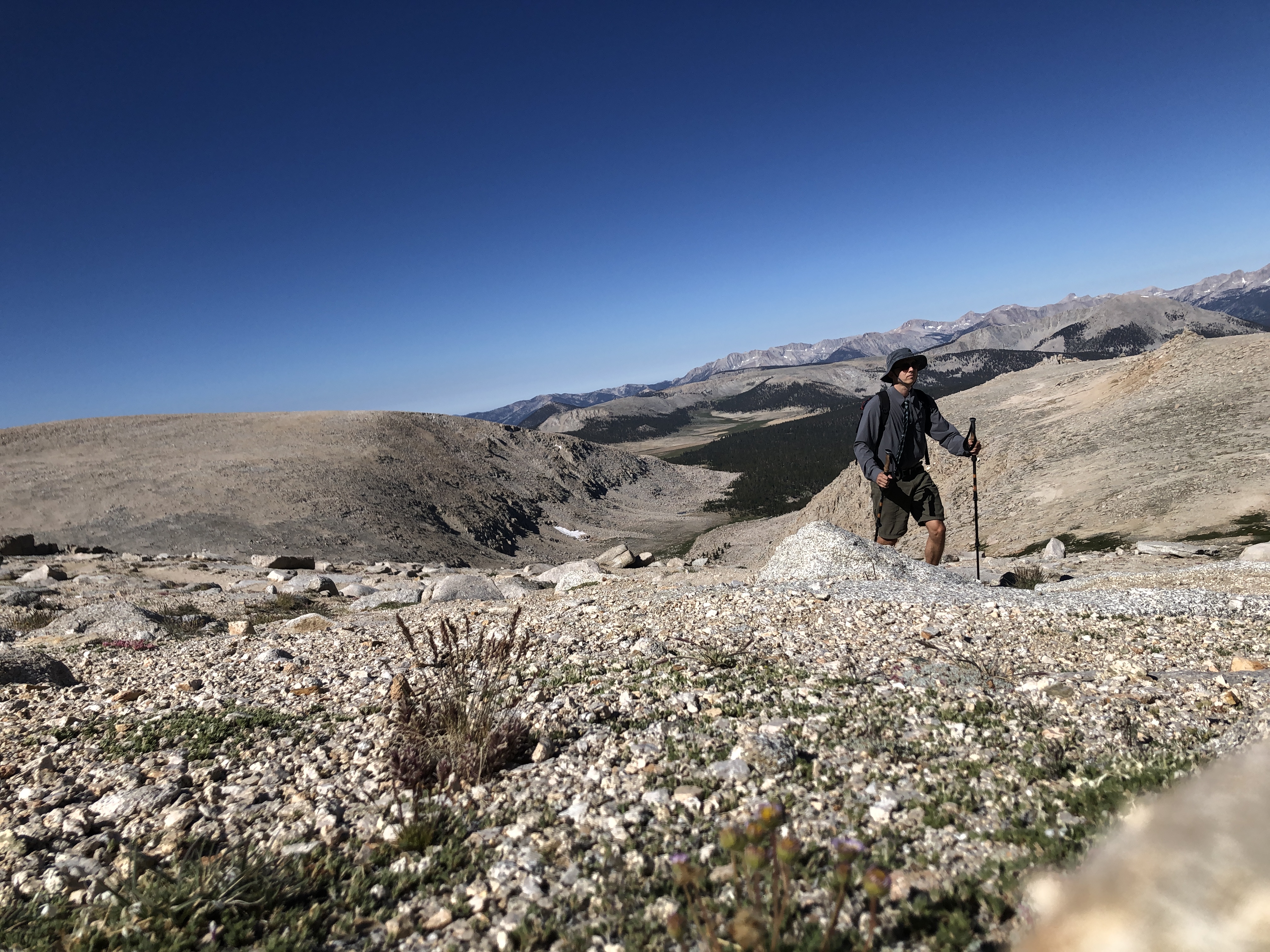
I reached a brief downhill section, passed the junction with the Red Reef trail, zoomed past Elder Camp (at least I think that's what it's called), and then spun out like nobody's business on the last uphill to road's end. I was spinning out so bad I finally called it quits and walked the rest of the way. By this point, my legs were beginning to feel a wee bit fatigued. But I was feeling much better than last time, so I decided to push on to the Bluff. The weather was holding up great, the breeze had kicked up a bit, and I still had plenty of water. I took a ten minute break, fueled up on more electrolytes, and then set off for the Bluff.
 |
| Road's end |
My idea was to ride up the trail to the saddle and then on to the Bluff. After 25 minutes I discovered this was not a good idea. The trail was steep, my tire bald. I found myself pushing my bike up the trail more often than I wanted to. So I turned around and went back to road's end. I ditched the bike and then set off on foot for the summit.
I backtracked down the road for a moment to the base of the western ridge. This is the shortest way to the top of the Bluff. I usually use this as a descent route because it's steep as all get out. I've only gone up it once, and that was another horrible experience. In fact, it was part of the worst hike I've ever done. Graveyard shift, poor sleep, poor nutrition, exhaustion, dehydration, hazy weather, high mileage. Yup, it sucked. But that's yet another story for later...
This time, things were much better. It looked like there had been some recent maintenance on the numerous switchbacks that cut up the side of the Bluff. Fresh cut marks and boot prints dotted the trail, the views to the south and west expanding with each step. I made it halfway up and took a brief break, my legs on fire after biking up Sisar and now climbing the steep grade. I pushed on, one step after another leading me to the summit.

 |
| Final push |
 |
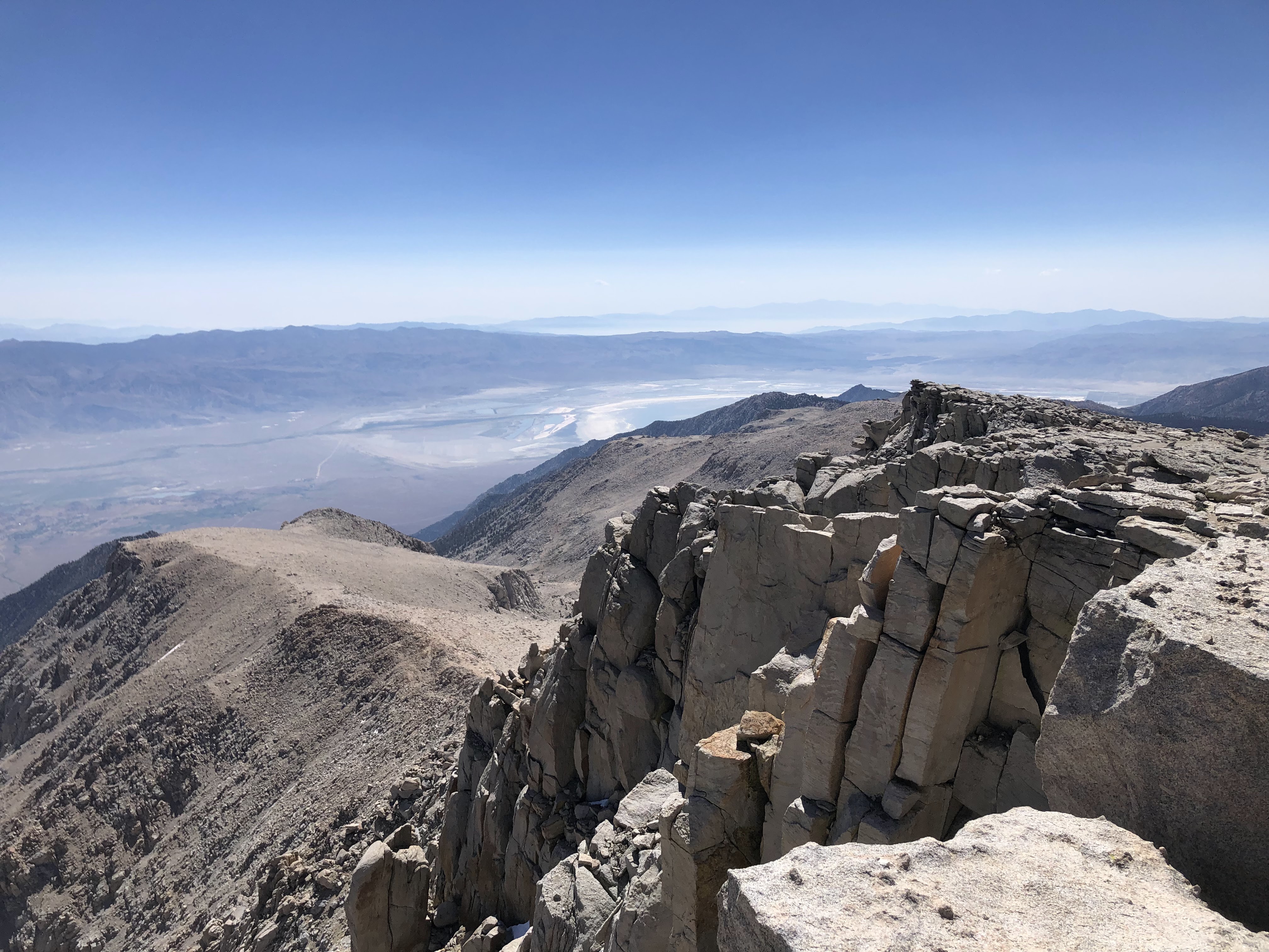
| The summit |
There's a pile of rocks and a bench made of flat stones on the summit. I conked out on the bench, suckin' wind and stretching my legs. I hadn't been on the Bluff in over three years, so it was nice to reacquaint myself with the view. It was a pretty clear day, with most of the haze resting near the coast. I could make out much of Santa Paula, the Oxnard Plain, the Santa Monica Mountains, Ventura, Lake Casitas, Lower and Upper Ojai. Chief Peak sat far below, a little slanted point jutting out on a long, rugged ridge. White Ledge Peak, Old Man Mountain, Monte Arido, and Madulce Peak could be seen to the west. Reyes Peak, Haddock Mountain, Thorn Point, and the mountains of the San Emigdio Range could be seen as well, looking rugged, hot, and distant.


I didn't spend too long on the summit. Said my goodbyes and then hightailed it back to road's end. On my way down I saw a very strange lookin' plane flying up from Santa Paula over to Nordhoff ridge. It was tiny, blue, and made a lot of noise. Almost looked like a drone, but I could see a single pilot situated in the cockpit. It disappeared down the ridge and I never saw it again.
Back at road's end I nabbed my bike and checked my tire pressure. In addition to the rear tire being nearly bald, the front tire had a slow leak. It normally took 8 hours for it to get completely flat, but you never know what could happen. After checking it, there was definitely less air than when I started, but it would be fine for the way down. I hopped on and rolled down the ridge road, beginning the exhilarating descent.
 |
| Headin' back |


At first, things were going great. I was zooming down the road, the wind in my hair, no more fatigue, no more sweat. Just sweet, sweet, downhill. And then I was back at the junction with Sisar Rd. And that's when my brakes decided to die.
When I rode off of Hi Mountain earlier this year, I noticed that my brakes were nearly cooked. I was almost pressing them against my handlebars. But they worked just fine and got me down the road no problem, Since then, I figured that they still had some life left in 'em. Figured they'd last just a little longer. Figured they'd take me down Sisar no problem. Whelp, my brakes had other plans. Decided that it was time to die. And so they did.
There wasn't a funeral. No remarks, no final words. I white-knuckled my way down Sisar, pressing the brake levers against the handlebars as tight as I could, squeezing every last bit of resistance out of my dead brakes.
I almost crashed a few times. I'd round a corner and couldn't slow down fast enough, taking a wide turn onto the side of the road. Just before making it back to the shady section, I saw an old guy with a towel around his neck zooming up the road on an electric bike. I didn't envy his electricity. I envied his brakes. I lost all resistance just past Howard's Place. I hopped off the bike in a sprint and slowed it down to a walk. Dang. Now I had to walk the whole rest of the way back.
 |
| Walkin' the bike |

It occurred to me that I could tighten the brakes by loosening the screw near the handlebars. Why I didn't think of this sooner I do not know. But by that time my grip was shot from white-nuckling it down most of Sisar, so I couldn't unscrew nothin'. There were brief sections where it was flat enough to glide, so I hopped on the bike and rode for a bit until it got steep. As soon as it got steep, I'd hop off in a run and slow down to a walk.
I didn't see anyone else out on the road until I got to the parking lot. There was a family walking back from the creek, the toddlers running around like crazy. I took my chances on the asphalt and glided the rest of the way back, hopping off the bike at Highway 150.
Aside from the break malfunction, it was a very good day, much better than my last ride up Sisar. Views were great, weather wasn't too bad. I might just do it again in the future, although in all honesty I kinda prefer hiking in the mountains over biking in the mountains.